
Aerial Photogrammetry
Aerial Photogrammetric analysis may be applied to a single image or high-speed imagery and remote sensing to detect, measure, and record complex 3D motion fields. This is done by feeding measurements and image analysis into computational models that estimate the relative motions and positions with increasing accuracy. While it was primarily used for topographic mapping in its early days, its application base has recently expanded into numerous industries. Modern sensors and software capabilities allow for precise 3D renderings and point cloud generation, and they are widely used in filming, sports, game development, agriculture, real estate, forensics, land surveying, and civil or architectural engineering. For these different applications, two photogrammetry methods are used in practice today: Aerial Triangulation (AT) and a more modern approach, Direct Georeferencing.
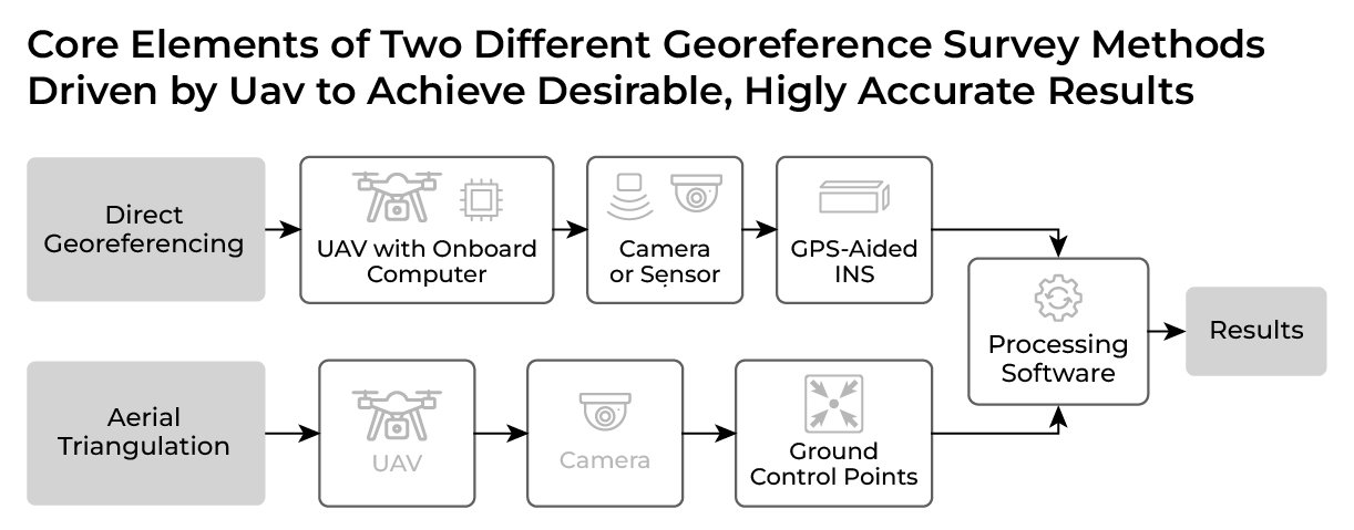
Aerial Triangulation
Aerial Triangulation is the process of optimally piecing together a block of overlapping aerial images so that you can make a map. The objective is to determine the position and orientation of each image in a mapping frame. This is done by using Exterior Orientation (EO) parameters. Once these parameters are acquired, you can measure the relative positions and locations of ground objects. Conventionally, AT uses Ground Control Points (GCPs), which provide reliable position data but at the cost of geometrical accuracy depending on the quantity of GCPs used and their spatial layout configuration. This puts constraints on project time management and limits cost-effectiveness.
Direct Georeferencing
Similarly, Direct Georeferencing uses high-grade Inertial Measurement Units (IMUs) and an optional Global Navigation Satellite System (GNSS) receiver and, as a result, provides an absolute orientation to a continuous ground reference with a high level of accuracy. Such aerial surveillance allows for minimized efforts in data collection for a larger landscape and access to surveying a location where GCPs are not deployable. During all this, it also ensures that time and finances after initial investment are not wasted.
Limitations of Aerial Triangulation with GCPs
GCPs are used to help relocate images into local coordinate systems. Even though GCPs may seem to be a cheaper option at first sight, they are limited in their usability and create a tremendous amount of extra work in the long run. Installing and maintaining GCPs around a tiny plot of land may be worth tackling. Still, an alternative method becomes desirable when it comes to more significant or complex landscapes where manual installation of GCPs is nearly impossible.

Tedious routines for pre-surveying can heavily tap into your budget:
With GCPs, generally, every survey is preceded by laborious preparation. The steps for this method of surveying are as follows: First, GCPs get installed throughout a field/landscape evenly; then, a professional surveyor (or you can purchase equipment to do it yourself) will identify the exact location of every GCP by using a precision GNSS receiver with antenna(s) to save coordinates for processing data; finally, only then a surveying flight can begin to create mappings using known positions. Setting up GCPs for every survey, in some cases, is time-consuming and may even be dangerous. In instances where GCPs are installed permanently, extra maintenance is required because unsupervised GCPs may get blocked by a growing plant or moved from its location due to wind or curious wildlife, which would cause a need for another surveying expense. Either way, additional manpower must be invested continually.
Time spent on GCP placement and its coordinates survey is the main disadvantage of this approach
Apparent cost savings may turn out to be more expensive than you thought:
A high-end set of GCPs to survey a landscape may total up to several thousand US dollars. Build them yourself, and unless your GCPs have embedded GNSS receivers, you’ll consistently be re-coordinating the locations before every survey for consistent accuracy. Either way that adds up to quite an expense in terms of time and effort. In the long run, such an approach may make an alternative method requiring much less effort more appealing. Using an all-in-one product like GPS-Aided INS avoids the hassle of GCPs.
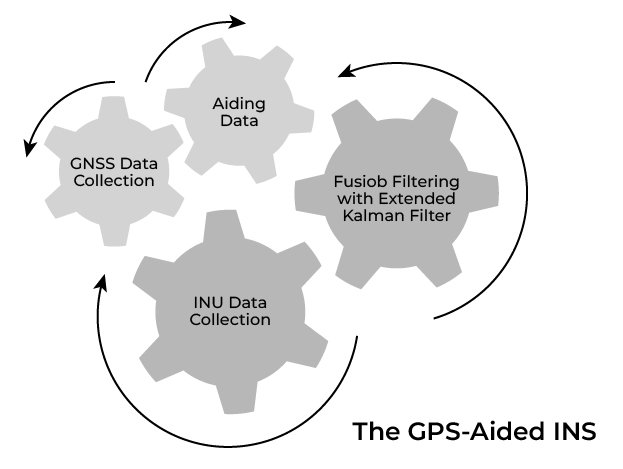
Direct Georeferencing with GPS-Aided INS
Direct Georeferencing with a GPS-Aided INS is used for aerial photogrammetry when traditional methods aren’t efficient enough for the application. Unmanned Aerial Vehicles (UAVs) often use a GPS-Aided INS with aiding data from a high-resolution camera/laser to capture and map the Earth’s surface accurately. For Inertial Labs, these GPS-Aided INSs include features like:
- Embedded GNSS receiver, with up to 1 cm + 1 ppm RTK position accuracy
- Powerful Magnetometers with correcting data from high-grade Gyroscopes (1 deg/hr bias in-run stability) to provide 0.05 deg GNSS Heading and <0.4 deg Free-inertial Heading accuracy (3 sigma)
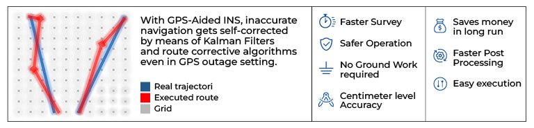
- Powerful self-correcting algorithms, such as an advanced Kalman filter for precise navigational and orientational computations
Faster Data Processing with GPS-Aided INS
In the long run, Direct Georeferencing with GPS Aided-INS is the most pragmatic approach to aerial photogrammetry. With the time savings and ease of operation, the upfront start-up costs pay for themselves by allowing you to focus your time on what matters, the results. Direct Georeferencing with a GPS-Aided INS has another advantage for applications where time data processing is time-sensitive. Data acquired by UAVs using GPS-aided INS-equipped UAVs is processed faster than similar data acquired using a GCP approach. This is because the GCP approach must stitch together layers of data using the known positions of only the GCPs with aided imagery. However, when using a GPS-Aided INS, the position is consistently monitored in real-time, allowing for faster processing times between images and positions.
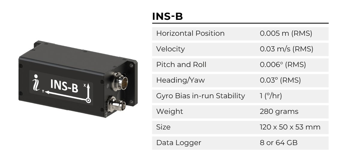
Standalone Solution: INS-B
The Inertial Labs GPS-Aided INS-B is a new generation of integrated, combined GPS, GLONASS, GALILEO, QZSS, BEIDOU, and L-Band navigation and high-performance strap-down system that determines Position, Velocity, Pitch, Roll, and Yaw with high accuracy for both motionless and dynamic applications. It utilizes an advanced single antenna GNSS receiver, barometer, 3 axes each calibrated in full operational temperature range precision Accelerometers and Gyroscopes. It is also armored with a sensor fusion filter, state-of-the-art navigation algorithms, and calibration software. The INS-B can even aid data for optical cameras, autopilot, or Light Detection and Ranging (LiDAR) payloads to help further take your application to the next level.
The Value of Investment
Depending on the application and factors of the project there are two main approaches to producing mappable results. Direction Georeferencing using the Inertial Labs INS-B provides a solution that mitigates groundwork, reduces risk, and delivers faster results that are consistently accurate. For alternative results acquired using GCPs, potential money saved on startup costs may come at an expense in the long run in continual maintenance and repeated expenses. For professionals who frequently perform routine operations, a GPS-Aided INS-B is the logical choice for its ease of data acquisition, speed of processing, and accuracy. Time is money; and in an industry where maximizing your ability to automate unnecessary work comes with heavy benefits, why not take that next step? By doing this, it allows human resources to be focused on the things that can’t be automated like interpreting results and building a more significant customer platform.


