
Evolution of Remote Sensing
Remote sensing emerged more than 150 years ago, as balloonists took pictures of the ground using the recently invented photo cameras in the 1840s. Perhaps the most memorable breakthrough in the field at the end of the 19th century was the famous fleet of pigeons that operated as an innovation in Europe, taking pictures with cameras attached to their bodies. By the First World War, cameras on airplanes provided aerial views of vast surface areas, which proved invaluable in military reconnaissance. The aerial photograph remained the standard surface imaging tool until the early 1960s.

The latest progress in laser and microprocessor technologies has ignited an emerging generation of affordable and compact mapping solutions employed by several businesses across industries, including construction, agriculture, surveying, mining, and more. Nowadays, remote sensing is performed on various moving bases, including cars, drones, and robots like LS3 by Boston Dynamics. Automakers rushing to develop the most efficient self-driving vehicles are encouraged to employ remote sensing technologies as never before.
Area Mapping

Perhaps area mapping is still the most significant domain for remote sensing. Making sense of the physical world by analyzing maps and 3D models allows businesses to make faster and more informed decisions that increase efficiency and profit and, more importantly, improve safety. A few of the most often used bases on which it can be used are land vehicles or unmanned aerial vehicles (UAV). Both options come with their pros and cons.
Choose the Right Drone
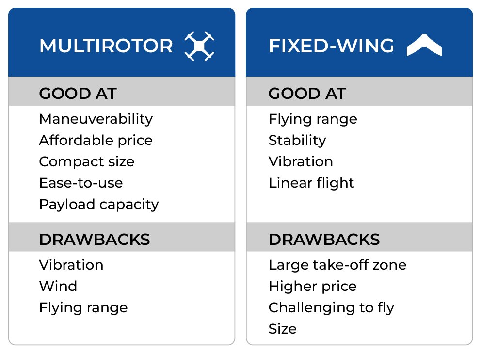
Even though a land vehicle can cover vast areas, a disadvantage is that many places to be mapped have impassable surfaces, like jungles or rocky mountains. With prices for UAVs going down, it’s no surprise that drone use is on the rise as an alternative for capturing aerial data and generating accurate 3D models of surroundings.
Importance of Precision Point Cloud

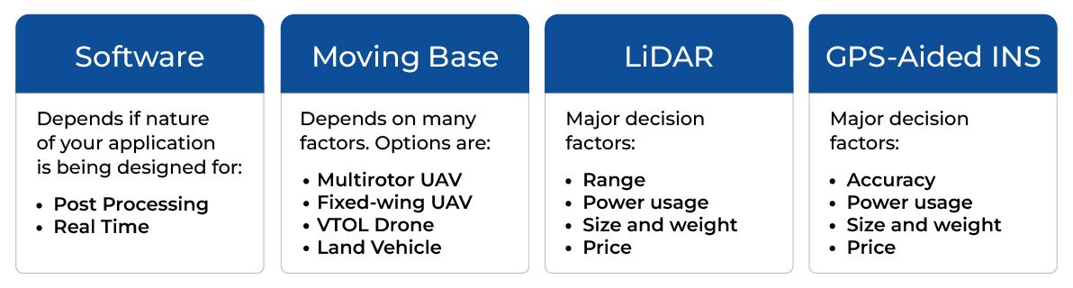
Accurate precision point clouds are the most critical aspect of remote sensing. The ultimate goal is to reach maximum accuracy for point clouds over the minimum scans. The key requirement is the reliability of gathering data and raw data accuracy. Depending on the nature of your business, you may need data transmitted in real-time or recorded for post-processing. Ultimately, deciding which approach is best for your business needs would be best. In the case of real-time data processing, you sacrifice accuracy. Highly accurate real-time data processing is possible, though there is more chance for errors, and the accuracy will always be worse than post-processing the data. Generally, accuracy is expected to be poorer when using real-time methods, and the accuracy requirements of the project will dictate whether real-time methods can be used. When precision is the topmost priority, post-processing is the method to use.
Post-Processing Software

If your resources are invested in post-processing, you can slightly sacrifice point cloud accuracy while gathering data. Several powerful software packages are designed for post-processing to compensate for lost points by extrapolating some data. One example is Inertial Explorer®(1), developed by NovAtel Inc. Waypoint Products Group. It’s a Windows-based program suite provides GNSS (Global Navigation Satellite System) and inertial data post-processing. It may come preconfigured with aerial, land vehicle,e and marine processing profiles that help new customers get started quickly.
LiDAR

Sometimes called a 3D laser scanner, LiDAR is a surveying method that measures distance to a target by illuminating the target with pulsed laser light and measuring the reflected pulses with a sensor. It has terrestrial, airborne, and mobile applications. Some models of 3D LiDAR can generate up to 700,000 data points per second; there are plenty of exceptional producers on the market, such as Quanergy®(2) and Velodyne®.
GPS-Aided INS
Based on cost-effective MEMS technology, the Inertial Labs Single and Dual Antenna GPS-Aided INS is a new generation of fully-integrated, high-performance strapdown systems. Inertial Labs GPS-Aided INS utilizes a GNSS receiver produced by NovAtel®, a barometer, 3-axes each of temperature-calibrated precision, tactical grade Accelerometers, and Gyroscopes to provide accurate orientation. Inertial Labs GPS-Aided INS contains a new onboard sensor fusion filter, state-of-the-art navigation and guidance algorithms, and calibration software.
Single GNSS antenna INS for post-processing kinematics (PPK)
Dual GNSS antenna INS for real time kinematics (RTK)
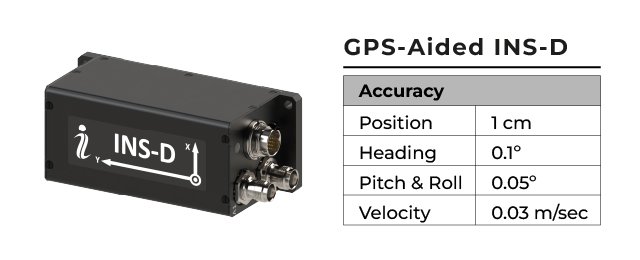
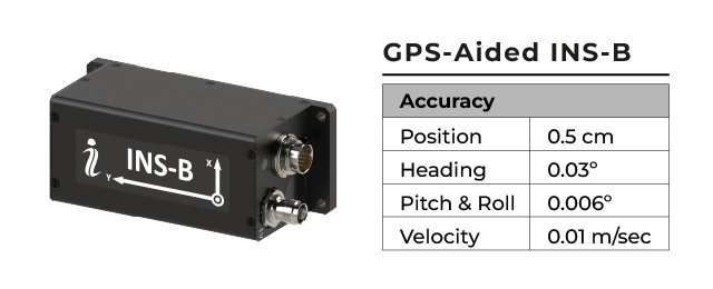
Depending on specific needs, the GPS-Aided INS comes within different parameters to match your business goals most efficiently. A broad spectrum of options is available in the INS-B product line. Inertial Labs has got you covered. Inertial Labs has experience delivering not just GPS-aided INS but also the complete payload (Remote Sensing Payload Instrument – RESEPI.)
Test Results
INS Model: INS-B
Flying Platform: DJI Matrice 600 Pro
GNSS Receiver: NovAtel® OEM-7
Types of IMU: 1°/h, Tactical Grade
Post-Processed: Inertial Explorer® software


To Sum Up
The primary goal in remote sensing is to pick the correct set of core elements, integrate them into a solution, and, as a result, achieve the desired precision point cloud. Last but not least, all must be done within the shortest period and at the lowest price so as not to exceed the budget.

The core elements for remote sensing are the same whether it’s a solution for surveying power line corridors, pipeline inspection, precision agriculture, etc. While there are plenty of products on the market to choose from, the roadmap to a successful outcome goes through several critical points:
Remote sensing has increased significance in modern society. Data for civil, research, and military purposes is being gathered and processed for better decision-making. Photogrammetry, area mapping, surveying, inspection, and reporting are a few examples of remote sensing applications. According to Market Research Future Analysis, the global remote sensing technology market will be valued at approximately $18 billion by the end of the forecast period, from 2018 to 2023.


