Understanding the Problem
Inertial Labs has produced high-accuracy Inertial Navigation Systems (INS) at the world’s best price-performance ratio for years. An INS estimates the position, attitude, and velocity using the gyroscopes and accelerometers inside an inertial measurement unit (IMU). Position accuracy can be significantly improved when the INS is aided by the Global Navigation Satellite System (GNSS). However, GNSS is not always available. Customer requirements demand for better performance of an INS during GNSS outage. Outages occur from natural environments like tunnels, urban canyons, and roads under bridges or forced conditions like GNSS jamming or spoofing. During a GNSS outage, position error growth is inevitable. Inertial navigation using any IMU will accumulate errors due to integration and double integration of unknown accelerometer and gyroscope biases. Using GNSS allows the INS to estimate and correct these biases. However, bias instability and noise still cause drift when satellite communication is lost. A typical INS using a MEMS-based position solution would drift by thousands of meters over 20 minutes of GNSS outage; a navigation-grade IMU INS, like Northrop Grumman LN-100G, which uses high accuracy ring laser gyros, claims to drift 120 meters after a 20-minute GNSS outage. Instruments like this are too large, expensive, and power-hungry for most applications, especially emerging ones.

As a proven effective alternative, Inertial Labs developed the Tunnel Guide feature for the GPS-Aided INS: an advanced algorithm that implements continuous dynamic modeling for land vehicle motion. As a result, the INS can mitigate errors and increase the accuracy of its MEMS IMU during prolonged GNSS outages. No, the position error of a land vehicle remains low even in a GNSS outage area such as a tunnel, a city with signal-blocking buildings, or any location where satellite communication is being blocked, spoofed, or jammed.
The Tunnel Guide feature has proven to be an effective solution for military vehicles such as Infantry Carrier Vehicles (ICV), Mobile Gun Systems (MGS), Anti-Tank Guided Missile Vehicles (ATGM), Anti-Drone Guided Missile Vehicles (ADGMV), NBC Reconnaissance Vehicles (NBCRV), Assault Amphibious Vehicles (AAV), and Light Armored Multipurpose Vehicles (LAMV).

An Effective Solution
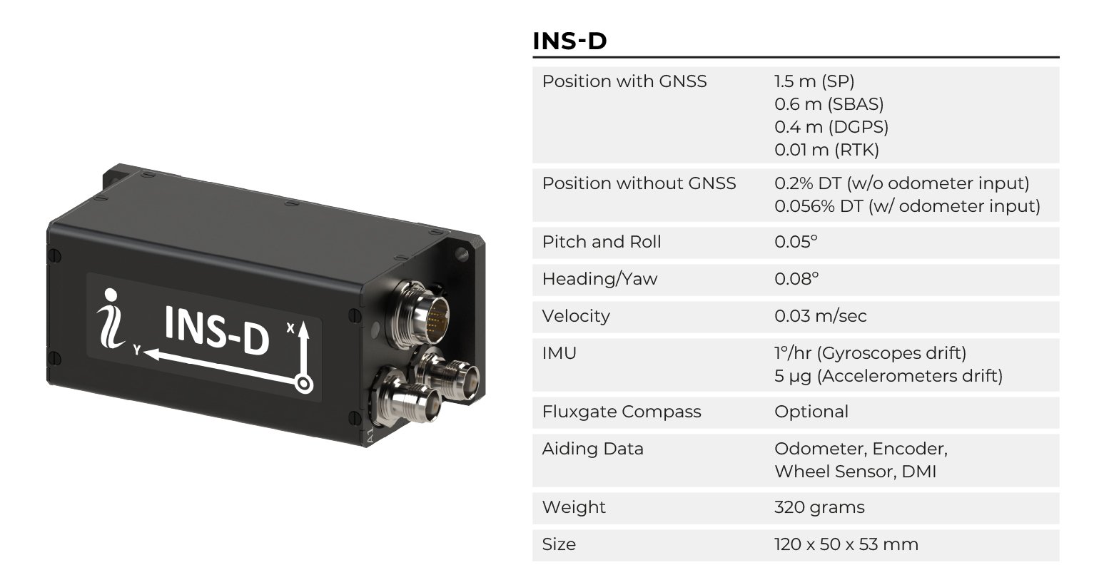
Sample data was gathered to demonstrate the effectiveness of Tunnel Guide for different application methods in purely inertial mode, only using inertial sensors together with sophisticated modeling of land vehicle motion. For both sample sets, a driving test was conducted using an Inertial Labs INS-D with Tunnel Guide without any aiding data from a Distance Measurement Instrument (DMI). The first test was run on a highway, driving at an average speed of 60 mph (96 km/h). The plot below shows an accumulated drift of approximately 160 meters, with an outage time of 25 minutes. This leads to an approximate drift rate calculation of 0.4% of Distance Travelled (DT) for a 25-minute outage. This is already comparable to a navigation-grade INS (120-meter drift over 20-minute outage), yet the size, weight, power, and cost are an order of magnitude lower.

Tunnel Guide will improve its accuracy for applications involving more frequent turns.
A plot from another sample test was produced similarly, but in this situation, the vehicle was driven in a city environment. This sample set shows the compelling nature of Tunnel Guide when vehicle dynamics allow better observability of the system state. This driving test was done at an average speed of 25 miles per hour (40 km/h) with frequent turns, and the GNSS outage lasted for 30 minutes. The plot below shows the performance of the INS using Tunnel Guide with no aiding data from a DMI.

The average drift rate of the second sample set was calculated to be 0.2% DT throughout the 30-minute outage with a peak drift of approximately 45 meters. These results show that Tunnel Guide significantly improves performance accuracy during GNSS outages at a much lower cost.
Improved Accuracy with Aiding Data
A driving test was performed similarly to the previous test to test the filtered navigation solution, using aiding data directly from a vehicle’s OBD-II port via CANbus. The vehicle was driven at an average speed of roughly 20 miles per hour, and a GNSS outage was simulated 15 minutes into the drive. After 30 more minutes of driving under GNSS-outage conditions, the device was given GNSS corrections again, and the solution converged. Above is an image of the test route that was driven.

Data was then processed in NovAtel Inertial Explorer. A post-processed solution utilized IMU data from the INS-B and the recorded GNSS data. This data was independent of the INS navigation solution and was used as reference data to compare the results of the simulated GNSS-outage.


A second plot was also generated to show the trendline for horizontal position error as a function of distance traveled. This plot is proper because it is critical for land-based navigation systems operating in a GPS-denied environment. This plot is shown below.

From these plots, it can be concluded that the usage of CANbus aiding data in the INS-D Kalman filter resulted in a horizontal position error of 0.056% DT, which is a significant improvement on the 0.2% found in the test mentioned earlier. Now, users can be confident that even in an extended GPS-denied environment, systems can navigate autonomously with accuracy that outperforms any comparable sensor in the industry.
Regardless of your land vehicle application, keeping accuracy during a GNSS outage can be the deciding factor in meeting the expectations of your project requirements. For Inertial Labs, developing the Tunnel Guide feature is a solution that provides increased position accuracy without increasing the cost of our devices. The GPS-aided INS-D is Inertial Labs’ dual antenna INS unit, but with it comes accuracy and advanced features that ensure that saving money doesn’t mean cutting corners on performance.