Abstract
This article examines the revolutionary impact of laser scanning technology on various industries. LiDAR (Light Detection and Ranging) provides highly accurate measurements, speeding up surveying, construction, agriculture, mining, transportation, ecology, and cultural heritage preservation processes. The article analyzes the key benefits of LiDAR, including creating 3D models, monitoring objects’ conditions, and using drones for hard-to-reach locations. Real-world examples of applications, from archaeological discoveries to improving safety on power lines, are pointed out. The conclusion emphasizes how integrating LiDAR with modern technologies such as BIM and autonomous systems transforms traditional approaches, making them more accurate, cost-effective, and sustainable.
Here are sections that will be reviewed: “What Is LiDAR and How Does It Work?”, “How LiDAR’s transformative impact on various industries?” and see also “RESEPI GEN-II from Inertial Labs. Key to efficiency”. Finally, the benefits of using LiDAR in various industries will be summarized.
Section 1. What Is LiDAR and How Does It Work?
LiDAR (Light Detection and Ranging) is a technology that uses laser pulses to measure distances to objects. The basic steps of LiDAR are as follows:
- A laser transmitter emits a short pulse of light.
- The beam reflects off the object’s surface and returns to the receiver.
- The time the pulse traveled back and forth is measured.
- The distance to the object is calculated based on the speed of light.
This process is illustrated in Figure 1. Measurement data is combined to create a highly accurate point cloud.
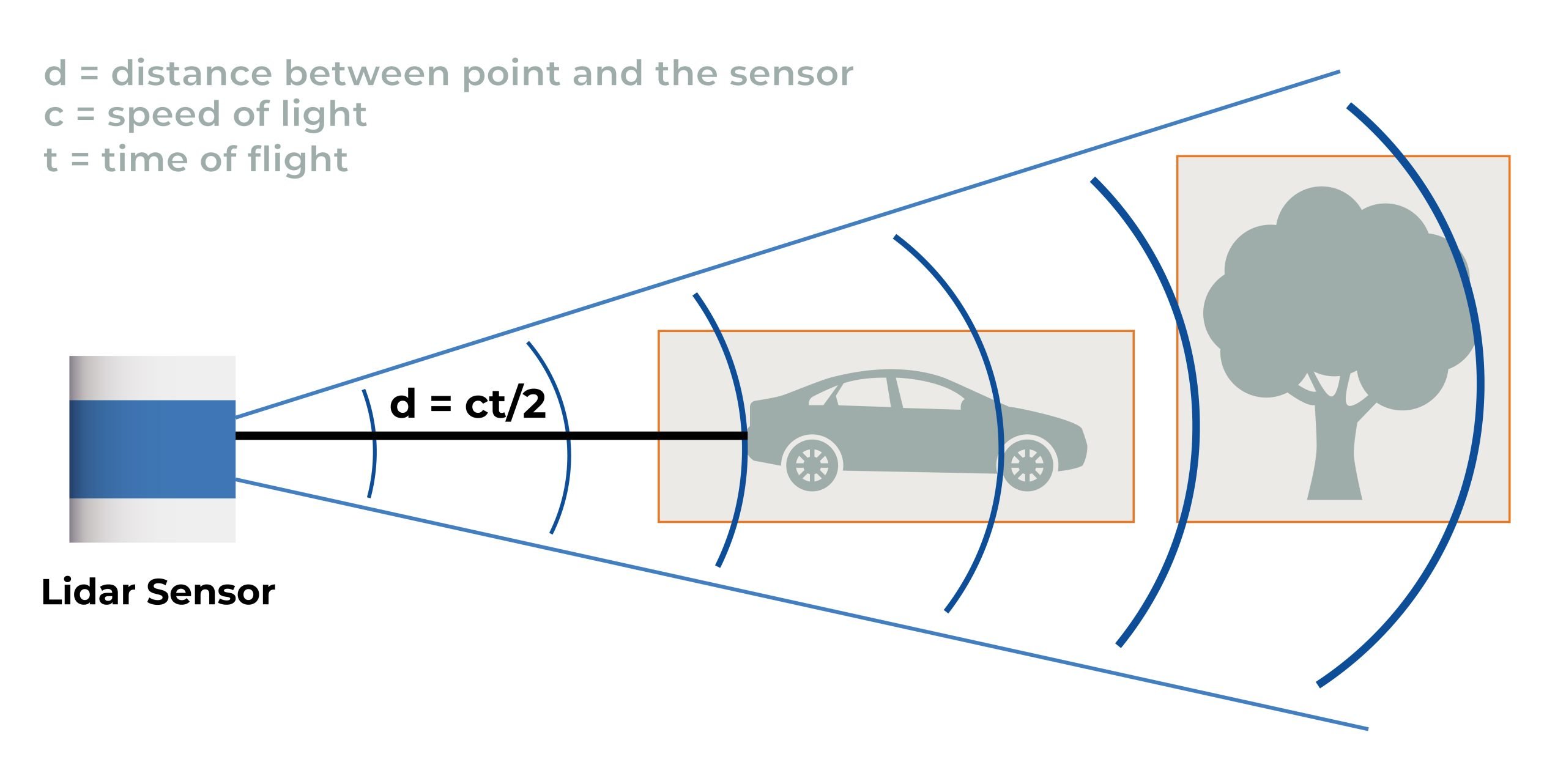 Figure 1. Conditional demonstration of LiDAR operation [1].
Due to the rapid development of technology and the high demand for miniaturized solutions, particularly for autonomous vehicles, solid-state LiDARs have entered the market. Solid-state LiDARs are a more modern version of LiDARs that do not use mechanical rotating components for scanning. Instead, they utilize fixed lasers and systems that provide “scanning” via electronic control. Bathymetric LiDAR’s are also worth mentioning. These operate at two wavelengths (infrared and green), allowing measurement of both terrestrial and underwater landforms, including the depths of bodies of water. Key features are summarized in Table 1 below.

Table 1. Key features of different types of LiDAR.
Due to its high accuracy, speed of operation, and ability to collect data in challenging environments, LiDAR has become heavily used in various applications, some of which are summarized in Table 2.
Table 2. Industries that use LiDAR.
As can be seen, there are a lot of them. This is due to the advantages of using the technology: high accuracy and speed of data collection, operation in the dark or poor lighting conditions, extended range of measurements (especially for LiDARs used on aircraft), and versatility (terrestrial and underwater scanning).
Thus, LiDAR has had a very significant impact on many fields. How exactly? We will look at this in the next section.
Section 2. How has LiDAR’s transformative impact on various industries?
LiDAR (Light Detection and Ranging) technology rapidly transforms how industries collect, process, and utilize spatial data. By emitting laser pulses and measuring the time it takes for them to bounce back from surrounding objects, LiDAR creates precise, three-dimensional maps of environments. This capability bridges the gap between traditional data collection methods and the need for real-time, high-accuracy information in various cases.
LiDAR in Autonomous Vehicles
ADAS (Advanced Driver Assistance Systems) is a combination of technologies aimed at improving the safety and convenience of driving. They include lane keeping, adaptive cruise control, automatic emergency braking, and obstacle detection.
The first steps towards creating modern ADAS systems were made in the 70s of the last century. At that time, antilock braking systems (ABS) were developed [2]. We know these systems are level 1 when a person still controls the vehicle, but the design provides various adjustments that help the driver. Later, electronic stability control systems (ESC), Traction Control Systems (TCS), and Cruise Control (CC) appeared [3]. Since then, many different miniature sensors have emerged, thanks to which modern ADAS have reached a new level. Today, most cars are level 1 or 2, with some models reaching level 3, where the car can drive itself in certain conditions (e.g., traffic jam assist (TJA)), but the driver must still be prepared to take control.
In heavy traffic and complex urban environments, autonomous vehicles must process significant information about the world around them. To do this, cars are equipped with various sensors, including radars, cameras, and LiDARs, Figure 2.

Figure 2. ADFAS Sensor [4].
These sensors complement each other to create a comprehensive driver assistance system. To ensure safe driving, the car’s computer must process data from all sensors in real-time. This allows it to form an overall picture of the environment, which helps the car adequately respond to vehicles, pedestrians, and other objects.
LiDARs play a key role in the concept of fully automated driverless vehicles. They allow vehicles to be fully automated in any driving conditions.
ADAS systems based on LiDAR, in combination with cameras and radar, allow complete control of the car, adjusting the speed and direction of movement to ensure maximum safety. Cameras are helpful in good visibility, performing tasks such as parking, and recognizing road signs and markings. Radar systems work effectively in low visibility conditions, providing an extensive range.
However, when a full 360-degree sensing of the space around the car is required, LiDARs demonstrate outstanding accuracy in recognizing objects and their shapes, even at large distances (100-200 meters). 3D mapping technology allows LiDAR to distinguish between cars, pedestrians, trees, and other objects and determine their speed in real time.
Fully autonomous systems (levels 4 and 5) are currently limited to test projects such as robotaxi and require further development of technology and infrastructure. Still, thanks to LiDAR, we may see fully automated (level 5) ADAS systems shortly.
LiDAR in Construction and Infrastructure
Due to its high accuracy and efficiency, LiDAR technology has not been spared from the construction industry. It has significantly improved project planning, monitoring, and management, making them faster, safer, and more accurate [5].
The use of LiDAR in the construction industry began with the active development of mobile LiDAR systems in the 2000s, due to which they began to be used to inspect roads, bridges, and other infrastructure facilities. LiDARs became popular in design, including creating 3D models of buildings and terrain. Since the 2010s, the technology began to be integrated with BIM (Building Information Modeling), which opened up new possibilities in design and construction management [6]. LiDARs were used to control construction quality, check project compliance, and determine the volume of work performed. Further development of drones simplified inspections of hard-to-reach areas, earthworks analysis, and construction monitoring.
Now, LiDARs continue to be actively introduced into construction due to their high accuracy, speed of operation, and the ability to integrate with digital technologies such as VR and IoT. Before LiDAR, data was collected manually, taking days or weeks. This work can be completed in a few hours, significantly reducing the time it takes to complete projects. This is especially important at the initial stages of design, where it is necessary to consider all the terrain’s features to prevent future errors.
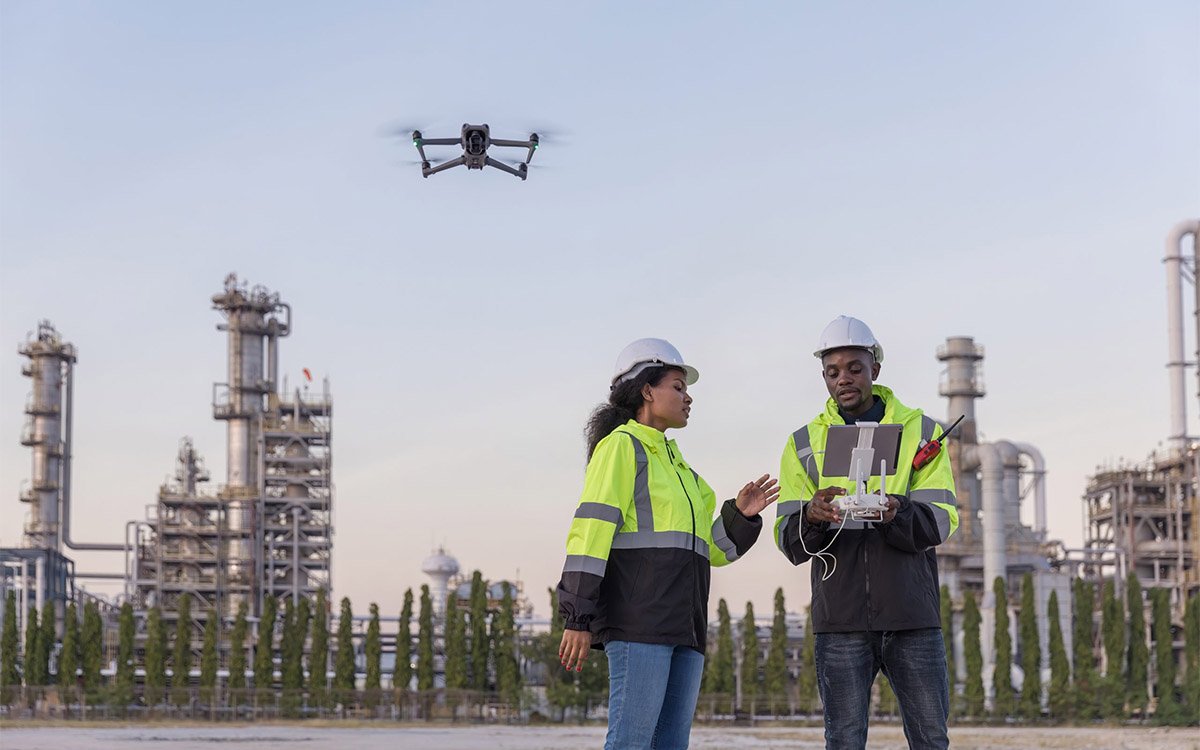
LiDAR is widely used to monitor the current state of a construction site, Figure 3.

Figure 3. Scanning the construction site with RESEPI.
It is used to check the compliance of completed work with design documentation, identify deviations from the plan, allow you to quickly make adjustments, and record the volume of work performed for reporting to customers or investors. This helps prevent the accumulation of errors and delays in construction processes, ensuring that the project is completed on time and within budget.
LiDARs are indispensable when surveying hard-to-reach or dangerous places for humans. This is important because construction can be planned even in rugged terrain, for example:
- Rock massifs and steep slopes, where manual surveying can be risky.
- Deep pits or tunnels, where it is difficult or takes a long time to lower people down.
- High-rise buildings that require special inspection equipment.
Using LiDAR in such cases ensures the safety of employees and saves time.
One of the key advantages of LiDAR is the ease of data integration into BIM systems. This allows you to create accurate digital models of buildings and infrastructure that reflect their actual condition, coordinate data between architects, engineers, and contractors, simplify collaboration, and analyze possible conflicts at the design stage (for example, the intersection of utility lines). BIM makes design more transparent and accurate, reducing the likelihood of errors at all stages.
The impact of technology on the industry and its benefits cannot be underestimated: saving time, reducing costs, improving the quality of the result under design requirements, and increasing safety.
LiDAR in Environmental Monitoring and Urban Planning
LiDAR has become an invaluable tool in both environmental monitoring and urban planning. Its ability to provide high-resolution 3D data on the earth’s surface allows for more informed decision-making and efficient resource management.
The use of LiDAR in environmental monitoring began with forest monitoring, biodiversity studies, and terrain modeling. In the 2000s, technologies made it possible to determine forest biomass and density, industrial emissions, fluorescence LiDAR sensing of seawater, and multispectral fluorescence imaging of facades [7]. LiDAR has gradually become a key tool for analyzing ecosystem changes, assessing carbon stocks, and identifying pollution.
LiDAR has been actively used in urban planning since the 2000s to create detailed 3D infrastructure models and optimize urban areas. They help plan road networks, place buildings, and analyze shading or flood risks [8]. Today, this data is used for sustainable urban planning and developing digital twins of cities, significantly improving territorial management.
Today, LiDAR is used to assess forest structure, biomass, and vegetation health, which will be discussed in more detail below. The technology can also help to identify and delineate wetlands by capturing detailed topographic data. This is critical for conservation efforts and regulatory compliance. Scanning effectively monitors coastal areas, providing data on shoreline changes, erosion rates, and habitat loss [9]. This information is vital for the management of coastal ecosystems.
Detailed and accurate digital elevation models (DEMs) are quickly and easily created from the scanned data necessary for flood modeling and risk assessment, Figure 4.

Figure 4. DEM was obtained from the point cloud with RESEPI.
This helps in flood protection planning and emergency response strategies. LiDAR data is used to create detailed 3D urban environment models, which can be used for visualization and modeling in urban planning. These models help understand the spatial relationships between buildings, infrastructure, and green spaces [10]. The data is also used to assess the condition of urban infrastructure, such as roads, bridges, and utilities [11]. This helps in prioritizing maintenance and upgrades. LiDAR data helps planners analyze land-use patterns and trends, allowing for more informed decisions on zoning, development, and resource allocation [12].
LiDAR can improve transportation planning by providing accurate data on terrain, road conditions, and traffic patterns, essential for developing efficient transportation systems.
LiDAR technology dramatically enhances the capabilities of both environmental monitoring and urban planning. Accurate, high-resolution data enables more effective decision-making and resource management, ultimately contributing to sustainable development and environmental protection.
LiDAR in Surveying and Mapping
Today, LiDAR is the primary tool for high-resolution mapping. At the beginning of the last century, mapping was done using traditional manual methods that were time-consuming and inconvenient, especially in heavily populated areas. LiDAR has revolutionized surveying and cartography by making these processes faster, more accurate, and more accessible.
The use of LiDAR in surveying and mapping began in the 1990s when technology first demonstrated its ability to quickly and accurately measure large areas. In its early stages, LiDAR was used to create topographic maps and survey hard-to-reach places, such as mountainous areas and dense forests, where traditional methods were impossible or time-consuming.
Since the 2000s, the development of mobile LiDAR systems has also opened up new possibilities, allowing surveyors to conduct surveys directly from the ground [13].
In the 2010s, LiDAR was integrated into geographic information technology (GIS) systems and has become an integral part of construction projects, especially in creating digital terrain models and infrastructure development. Modern mobile LiDAR platforms, such as drones, allow for precise surveys over large areas, including monitoring landscape changes and assessing the impact of construction on the environment.
We have already mentioned the speed of data collection. Still, in addition to this, LiDAR can penetrate foliage and vegetation, which allows you to obtain relief data in forested areas or tall grass. Remember to scan in hard-to-reach places: steep slopes and mountainous regions.
LiDAR provides highly accurate point clouds with a resolution of up to several centimeters. It allows you to measure relief, buildings, and vegetation with the highest detail, which is impossible using traditional methods.
The data collected by LiDAR is easily integrated into GIS and CAD software, allowing you to automate relief analysis, contour construction, and map creation. This eliminates human errors typical of manual calculations. Combining LiDAR with GNSS supplements cartographic information with georeference data. LiDAR mounted on aircraft or drones, allows for rapid coverage of large areas, creating topographic maps, determining the volume of earthworks, and recording landscape changes, such as the risk of landslides, subsidence, or coastal erosion. Comparing data collected at different times helps in risk assessment and planning.
It is also important that today, scanning data is also used to quickly detect and assess possible human casualties and damage to infrastructure because of various natural disasters—for example, earthquakes. During the aftermath of the Wenchuan earthquake, a range of equipment was used, as well as LiDAR [14]. As a result, it is noted that “It was demonstrated that high-resolution airborne and space-borne remote sensing data provided very effective and timely informative support in rescue efforts and disaster management concerning the Wenchuan earthquake.” Ultimately, the use of LiDAR in this area has contributed to the rapid and accurate execution of surveying and mapping work, reduction in survey costs, increase in coverage of territories, and improvement of data quality for infrastructure, environmental, and engineering projects.
Energetics and Powerlines
LiDAR plays a key role in the energy industry, especially in monitoring and managing power transmission lines (PTL). Its use significantly improves safety, accuracy, and efficiency.
With the advent of UAVs, monitoring of power lines has become more accessible and efficient. LiDARs have been used for regular inspections of the condition of wires and supports, contributing to the reliability of power grids. Since the 2010s, the technology has been actively used for automated monitoring of power lines. This included using drones to collect data, which was then processed using specialized software for analyzing the infrastructure condition, such as LiDAR360 [15].
Today, LiDAR is used to determine distances to objects such as trees that may threaten wires, assess the condition of supports and wires by creating 3D models, and audit and repair planning, which can significantly reduce the cost and time of inspections.
In addition to using LiDAR, there are other methods for monitoring PTL, which we discussed in the article [16]. Oddly enough, LiDAR has become an indispensable tool for monitoring power transmission lines in this area. Using LiDAR data, specialists can quickly assess the sagging of wires and the distances between cables and trees, helping to prevent short circuits and fires. Before building supports, data on the terrain and objects is fundamental, allowing you to lay out line routes optimally or eliminate potential problems in advance. LiDAR installed on drones or helicopters will enable you to inspect lines without disconnecting the network, which saves time and money, Figure 5.

Figure 5. Scanning a power line in hard-to-reach areas using RESEPI.
Regular scanning helps track changes (sagging wires, tree growth) and take timely measures. Assessing the effects of wind, ice, or thunderstorms on infrastructure is also essential in emergencies; quick shooting after accidents helps identify damage and speed up repairs accurately. Equally important is that you can quickly examine kilometers of power transmission lines thanks to aerial scanning, unlike manual methods.
Thus, LiDAR in the energy sector ensures the reliability of power transmission lines, increases their safety, and reduces operating costs, which is especially important for growing loads and climate change.
Forestry Management and Agriculture
LiDAR has significantly changed agriculture by offering new ways to collect data and analyze fields. Since the 2000s, LiDAR has become a standard tool in forestry for assessing timber reserves, monitoring ecosystem changes, and studying the impact of climate change on forest resources [17, 18].
The first experiments using LiDAR in agriculture aimed to create accurate field maps and analyze relief. This allowed farmers to plan irrigation and fertilization better. With the popularization of drones, the technology began actively monitoring crops’ condition and growth, creating field models for yield analysis, and optimizing agronomic practices based on the collected data.
Obtaining a 3D vegetation model helps identify problems with the growth and condition of plants, especially with large crops. As a result, farmers can optimize irrigation and fertilization. As with conventional mapping, LiDAR data helps create drainage and hydrography maps for more accurate irrigation planning. It also helps prevent overwatering and improves water distribution. LiDAR data is also valuable for crop management. Farmers can see where and what areas produce the best yields and where conditions need improvement.
Also noteworthy is that 3D maps, compiled regularly, can detect soil erosion and monitor plant growth. “After an aerial scan through software, crops can be removed from the point cloud to focus only on land flow by elevation. These visuals are often shown through the use and creation of contour maps. With this filtered, georeferenced point cloud turned into a Digital Elevation Model (DEM) or contour map, farmers can observe low elevation spots where water would tend to flow or gather, stealing the nitrogen fertilizer spread on the ground. Volumes, masses, and surface area can all be calculated to measure precisely where and how much dirt to move. A tractor or other advanced farming equipment can then accurately move and level the dirt in a known area.” [19]. LiDAR can also be integrated into agricultural machinery, helping to automate processes such as seeding and harvesting.
In the case of forestry, LiDAR can create detailed 3D models of forests. This helps researchers better understand the structure of the forest, including tree height, foliage density, and the distribution of different species, Figure 6.

Figure 6. Forest ground scanning with RESEPI.
Accurate data on tree height and volume help estimate forests’ biomass and carbon stock [20]. This is especially important for studies related to climate change and carbon credits. With the help of LiDAR, changes in forest cover, such as logging, fires, or diseases, can be monitored. This allows for rapid response to threats and restoration monitoring. The advantage of using LiDAR over photogrammetry is its penetrating ability, as shown in Figure 7.

Figure 7. Comparison between photogrammetric and LiDAR point clouds.
The data collected helps in forest resource management, allowing for more accurate planning of timber harvesting and other forest uses. This contributes to the sustainable development of forestry. It is also helpful for assessing species diversity, as it allows for detailed study of forest structure, including undergrowth and stands. This is important for ecosystem safety and reserve planning.
LiDAR has become an essential tool in forest monitoring and agriculture, providing more accurate and detailed data. This helps scientists, ecologists, and foresters better understand and protect forest ecosystems and effectively manage natural resources. Farmers can improve productivity and contribute to the more sustainable use of resources.
Archeology and Heritage Preservation
LiDAR has great importance in archaeology and cultural heritage conservation. Its use provides new opportunities for exploring, documenting, and protecting cultural heritage sites.
It helps to reveal hidden archaeological structures such as ancient roads, buildings, and other artifacts. One of the clear examples is the study of the sites at Baltinglass in County Wicklow, Ireland, Figure 9. «Using advanced LiDAR technology, archaeologists have created detailed three-dimensional models, revealing hundreds of ancient sites that have been destroyed by thousands of years of plowing.» [21].
Figure 9. Ancient monuments were discovered using LiDAR.
For example, in Guatemala, an operation was carried out using LiDAR to discover previously unknown Mayan structures, including pyramids and roads [22]. Also, LiDAR has been used in England to map ancient landscapes and find new archaeological sites [23].
LiDAR provides highly accurate point clouds of the terrain, which allows archaeologists to analyze geomorphological features and plan excavations.
Scanning data is vital for creating archives of the condition of cultural heritage sites. This is important for monitoring changes caused by time, natural phenomena, or human activity.
With the help of LiDAR data, archaeologists can restore lost objects by creating virtual models and reconstructions. This helps in understanding historical context and architectural styles. Handheld scanners are often used for this purpose [24]. LiDAR has become an essential tool in archaeology and cultural heritage conservation, opening new horizons for research and protection of historical sites. Its ability to accurately map and reveal hidden structures makes it indispensable in modern archaeological practices.
Mining and Quarrying
LiDAR simplifies terrain studies and quarry planning [25]. It is used to analyze, quantify, and orient faults [26]. Using LiDAR in the mining industry significantly improves management and monitoring processes. Highly accurate topographic maps of the terrain help plan mining operations and field development. This helps to minimize risks and optimize processes. The data is also used to create 3D models of fields, which helps estimate mineral reserves and plan production. This allows for a more accurate determination of where and how to mine [27].
LiDAR can be used to regularly monitor changes in quarries and mines, including assessing excavation volumes and waste accumulation. This contributes to more efficient resource management and reduced environmental impact. LiDAR can inspect infrastructure such as roads, dams, and other structures. This helps to identify potential problems before they become critical.
Thus, the technology provides the mining industry powerful tools to improve efficiency, safety, and sustainability. Its use allows for process optimization, risk reduction, and improved resource management, making it indispensable in modern mining operations.
As can be seen, LiDAR has been widely used since the 2000s with the development of affordable and compact systems. Further advances have allowed LiDARs to be installed on UAV cars or used for handheld scanning. Scanning technology has gained popularity due to its undeniable advantages, which have helped fill gaps and increase productivity in various industries. As it evolves, LiDAR will play an increasingly important role in shaping a future where data-driven decisions lead to smarter, safer, and more sustainable outcomes.
Section 3. EchoONE from Inertial Labs. Key to efficiency
Inertial Labs partnered with Teledyne Geospatial to launch EchoONE. This collaborative innovation combines Teledyne’s LiDAR and camera technology with the RESEPI sensing solution that leverages our IMU and INS technology [28]. Combining NDAA-compliant data security, lightweight design, and real-time operation to deliver long-range, engineering-grade 3D point clouds, EchoONE will drive reliability and return on investment for sensor operators across multiple applications, Figure 8.

Figure 8. TELEDYNE EchoONE (POWERED BY INERTIAL LABS RESEPITM).
TELEDYNE EchoONE Key Features
NDAA compliant
- EchoONE is compliant with FY2020 NDAA Sec 848 and FY2023 NDAA Sec 817
- EchoONE is designed, developed, and manufactured to be compliant with projects requiring the safety and security of data
Long-range LiDAR with up to 8 returns per laser pulse
- Powerful eye-safe laser with 270m range to 20% reflectivity targets
- Flexibility to map large areas quickly from a high operating altitude, capture narrow electric utility conductors or wires, and penetrate thick vegetation with returns from both tree structure and ground
Wide-angle perspective
- 90 deg horizontal field of view with 4 unique +/- 10 deg vertical scan angles
- Wide horizontal field of view maximizes swath, reducing flight time
- Vertical field of view captures utility poles and building walls
Precise data
- 5mm LiDAR ranging precision and 1.5cm georeferenced accuracy
- Low noise data results in crisp, detailed scans for modeling applications in utilities and transportation
Ultra-lightweight design
- Echo is the lightest weight UAV laser scanner with its performance
- Capture larger areas with increased flight time before needing battery swaps
- Compatible with smaller airline transportable UAVs and fewer transportation cases
Realtime georeferenced point cloud
- Georeferenced point cloud generated on-sensor in real-time
- Pilot QC review of LAS file to ensure project coverage before leaving the site
- Realtime API for third-party customized solutions
High-accuracy inertial measurement unit
- EchoONE includes the Inertial Labs KERNEL-210 tactical grade IMU
- High-accuracy inertial measurements ensure the accuracy and reliability of LiDAR point clouds when verified to ground control points
Integrated colorization camera
- EchoONE includes a 5MP global shutter camera and an optional 61MP camera
- Colorized point clouds provide additional context not available with intensity alone
- Optional 61MP allows for simultaneous capture of high-resolution imagery for ortho mosaics and inspection
Your projects deserve the best, and EchoONE will take your business to the next level!
Conclusion
LiDAR has revolutionized approaches in various industries, making processes more accurate, faster, and more efficient. Its versatility and ability to create highly detailed point clouds have opened new opportunities for science, business, and the environment. Integrating modern technologies such as drones and digital platforms makes LiDAR an indispensable tool for solving complex problems in construction, transportation, agriculture, archaeology, and other industries. The introduction of LiDAR highlights the trend toward digitalization and innovation that continues to transform traditional approaches, creating more sustainable and safer ways of working.
Experience the full benefits of EchoONE today! EchoONE is designed and manufactured in compliance with the latest NDAA requirements, ensuring data security while being competitively priced with less secure options. Echo weighs just 1.2kg and can be operated from smaller UAVs such as the Freefly Astro, Inspired Flight IF800, and DJI M300/M350 while operating reliably at a regulatory limit of 120m / 400ft AGL, delivering an accuracy of up to 1.5cm RMSZ, ranging precision of 5mm and 0.5mrad 1/e2 beam divergence resulting in clean and precise point clouds.
Adopting this technology will speed up processes, minimize errors, and open new horizons for your business. Let your project become part of the digital revolution – accuracy, efficiency, and innovation are now available to everyone. EchoONE is your step into the future!
References
[1] “Introduction to Lidar – MATLAB & Simulink.” Www.mathworks.com, www.mathworks.com/help/lidar/ug/lidar-processing-overview.html.
[2] Galvani, Marco. “History and Future of Driver Assistance.” IEEE Instrumentation & Measurement Magazine, vol. 22, no. 1, 1 Feb. 2019, pp. 11–16, ieeexplore.ieee.org/document/8633345, https://doi.org/10.1109/MIM.2019.8633345.
[3] Wikipedia Contributors. “Advanced Driver-Assistance System.” Wikipedia, Wikimedia Foundation, 24 Nov. 2024.
[4] Nagpal, Sankul. “ADAS Full Form: A Guide to Advanced Driver Assistance Systems.” Spinny Post, Spinny, 21 Oct. 2024, www.spinny.com/blog/adas-full-form/. Accessed 25 Nov. 2024.
[5] “The Impact of LiDAR Technology on Modern Construction Practices.” RESEPI, 31 July 2024, lidarpayload.com/the-impact-of-lidar-technology-on-modern-construction-practices/.
[6] Wang, Jun, et al. “Integrating BIM and LiDAR for Real-Time Construction Quality Control.” Journal of Intelligent & Robotic Systems, vol. 79, no. 3-4, 28 Sept. 2014, pp. 417–432, link.springer.com/article/10.1007%2Fs10846-014-0116-8, https://doi.org/10.1007/s10846-014-0116-8.
[7] Weibring, Petter, et al. “Versatile Mobile Lidar System for Environmental Monitoring.” Applied Optics, vol. 42, no. 18, 20 June 2003, p. 3583, https://doi.org/10.1364/ao.42.003583.
[8] Palmer, Trent C., and Jeffrey J. Shan. “A Comparative Study on Urban Visualization Using LIDAR Data in GIS.” (2002).
[9] “Integrating RESEPI Technology for Advanced Estuary Mapping.” Inertial Labs, Aug. 2024, inertiallabs.com/integrating-resepi-technology-for-advanced-estuary-mapping/.
[10] Fernandez-Alvarado, J.F., and S. Fernandez-Rodriguez. “3D Environmental Urban BIM Using LiDAR Data for Visualisation on Google Earth.” Automation in Construction, vol. 138, June 2022, p. 104251, https://doi.org/10.1016/j.autcon.2022.104251.
[11] Wang, Ruisheng, et al. “LiDAR Point Clouds to 3-D Urban Models$:$ a Review.” IEEE Journal of Selected Topics in Applied Earth Observations and Remote Sensing, vol. 11, no. 2, 1 Feb. 2018, pp. 606–627, ieeexplore.ieee.org/abstract/document/8253517?casa_token=L-W2NeWleScAAAAA:0rBzKVNZvDxzdV0Gf1bd-l2hDgxRztqz6PTEN4A8c8E6D6qVjtSHH_3_tMNerOolM0fYB6c2dA, https://doi.org/10.1109/JSTARS.2017.2781132. Accessed 25 Nov. 2022.
[12] Dudzinska, Anna, et al. “The use of LIDAR data to assess elements of rural landscape architecture.” Nauka Przyr. Technol. 11.4 (2017): #37. https://doi.org/10.17306/J.NPT.2017.4.37
[13] Olteanu, V., et al. State of the Art in Mobile Terrestrial Laser Scanning Systems in Romania and at an International Level State of the Art in Mobile Terrestrial Laser Scanning Systems in Romania and an International Level.
[14] The Wenchuan Earthquake. https://www.asprs.org/wp-content/uploads/pers/2009journal/may/highlight1.pdf
[15]GreenValley International. “LiDAR360 | Power Line Surveying and Management.” YouTube, 11 Aug. 2017, www.youtube.com/watch?v=gwBy6RMkHzg. Accessed 26 Nov. 2024.
[16] “Optimizing Powerline Inspection with Advanced LiDAR Technology.” Inertial Labs, 6 Aug. 2024, inertiallabs.com/optimizing-powerline-inspection-with-advanced-lidar-technology/. Accessed 25 Nov. 2024.
[17] Dubayah, Ralph O., and Jason B. Drake. “Lidar Remote Sensing for Forestry.” Journal of Forestry, vol. 98, no. 6, 1 June 2000, pp. 44–46, academic.oup.com/jof/article/98/6/44/4614333, https://doi.org/10.1093/jof/98.6.44.
[18] Abraham Aidoo Borsah et al. “LIDAR-Based Forest Biomass Remote Sensing: A Review of Metrics, Methods, and Assessment Criteria for the Selection of Allometric Equations.” Forests, vol. 14, no. 10, 19 Oct. 2023, pp. 2095–2095, https://doi.org/10.3390/f14102095. Accessed 24 Jan. 2024.
[19] “LiDAR Technology and Its Impact on Fertilization.” Inertial Labs, 10 June 2024, inertiallabs.com/lidar-technology-and-its-impact-on-fertilization/. Accessed 25 Nov. 2024.
[20] “Forestry Management Using LiDAR.” Inertial Labs, 24 June 2024, inertiallabs.com/forestry-management-using-lidar/. Accessed 5 Sept. 2024.
[21] Milligan, Mark. “Archaeologists Reveal Hundreds of Ancient Monuments Using LiDAR.” HeritageDaily – Archaeology News, 24 Apr. 2024, www.heritagedaily.com/2024/04/archaeologists-reveal-hundreds-of-ancient-monuments-using-lidar/151775.
[22] Canuto, Marcello A., et al. “Ancient Lowland Maya Complexity as Revealed by Airborne Laser Scanning of Northern Guatemala.” Science, vol. 361, no. 6409, 27 Sept. 2018, p. eaau0137, science.sciencemag.org/content/361/6409/eaau0137.abstract, https://doi.org/10.1126/science.aau0137.
[23] Milligan, Mark. “Unveiling Tartessos: Discoveries at Casas Del Turunuelo.” HeritageDaily – Archaeology News, 7 Oct. 2021, www.heritagedaily.com/2021/10/120-archaeological-sites-identified-through-aerial-lidar-mapping/141612. Accessed 25 Nov. 2024.
[24] S.L, Factum Arte. “Factum Arte :: 3D SCANNING for CULTURAL HERITAGE CONSERVATION.” Www.factum-Arte.com, www.factum-arte.com/pag/701/3D-Scanning-for-Cultural-Heritage-Conservation.
[25]Wuestefeld, P, et al. Reservoir Heterogeneity in Upper Carboniferous Tight Gas Sandstones: Lessons Learned from an Analog Study. 25 Feb. 2014, https://doi.org/10.2118/167793-ms. Accessed 26 Nov. 2024.
[26] “The Future of Efficient and Safe Mining with LiDAR Technology.” Inertial Labs, 8 Aug. 2024, inertiallabs.com/the-future-of-efficient-and-safe-mining-with-lidar-technology/. Accessed 25 Nov. 2024.
[27] Roe, Gene. “LiDAR Convergence Monitoring – Rio Tinto Diamond Mine.” LiDAR News, 25 June 2021, lidarnews.com/project-showcase/lidar-convergence-monitoring-rio-tinto-diamond-mine/.
[28] “RESEPI – LiDAR Payload & SLAM Solutions.” RESEPI, 12 July 2024, lidarpayload.com/.


