Abstract
Some users just starting to use the LiDAR system do not always fully understand this technology and how it works. Therefore, this paper will consider the operating principle of LiDAR, its application, and its advantages and disadvantages. The sections will be covered: Introduction, Operating principle and types of LiDAR, LiDAR Applications, Advantages and Disadvantages of LiDAR Technology, RESEPI. The conclusion will summarize the answer to the question, “What is LiDAR?”.
Introduction
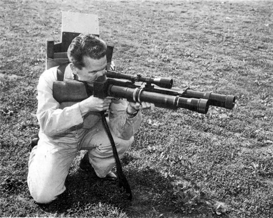
LiDAR (Light Detection and Ranging) technology has taken its start since the 60 ‘s years past century. A device like a gun was developed for the army’s needs, designed to determine the distance to targets, Figure 1 [1, 2]. Later, this technology was used in meteorology to assess pollution and measure clouds and in space to measure the distance from the Earth to the moon [3, 4].
How LiDAR Works
From that time to this day, this technology has remained virtually unchanged. It uses the same operating principle to determine range – measuring the time light travels from the emitter to the object and back to the receiver. Mathematically, this is expressed in a simple formula:
L = c * t / 2
where L is the distance from the lidar to the object, c is the speed of light, and t is the flight time.
Due to the physical properties of laser, LiDAR technology has found many new applications today; lidars are used in Agriculture, Archeology, Forestry, Mining, power monitoring, Geology, and many other spheres. Next, let’s look at the operating principle of LiDAR.
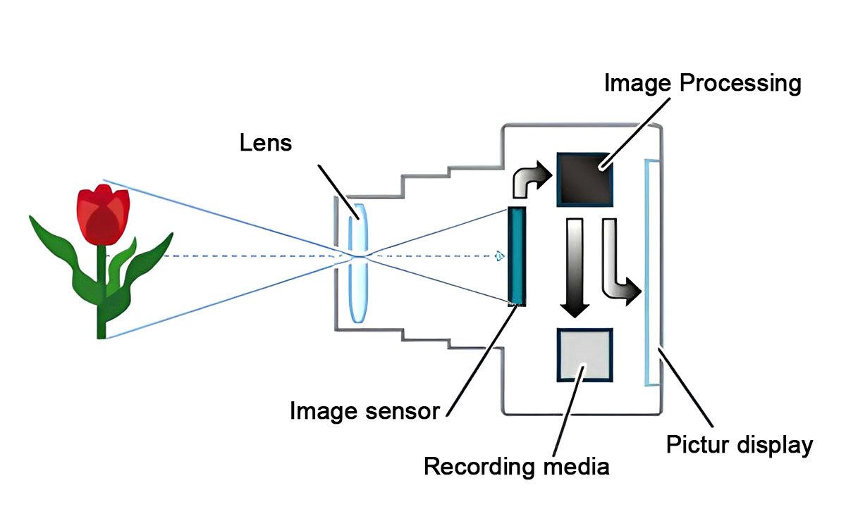
Before lidars were invented, cameras were used to photograph objects. This method is called photogrammetry [5]. The camera records reflected light with a light-sensitive matrix and based on this, forms an image, as shown in Figure 2 [6].
Unlike a camera, LiDAR has an infrared light source with a wavelength of 905 nm or 1550 nm for terrestrial and aerial scanning. There is also LiDAR for underwater scanning, the so-called bathymetry [7]. The wavelength of such lidars is 515 nm. This difference is due to the penetrating properties of infrared radiation. The 905 and 1550 nm lengths have extreme attenuation when entering water. It is also worth noting that some lidars can use wavelengths other than those listed here, such as 903 nm.
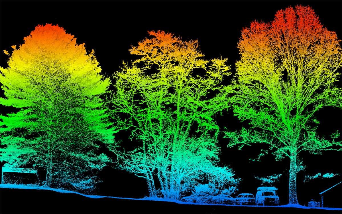
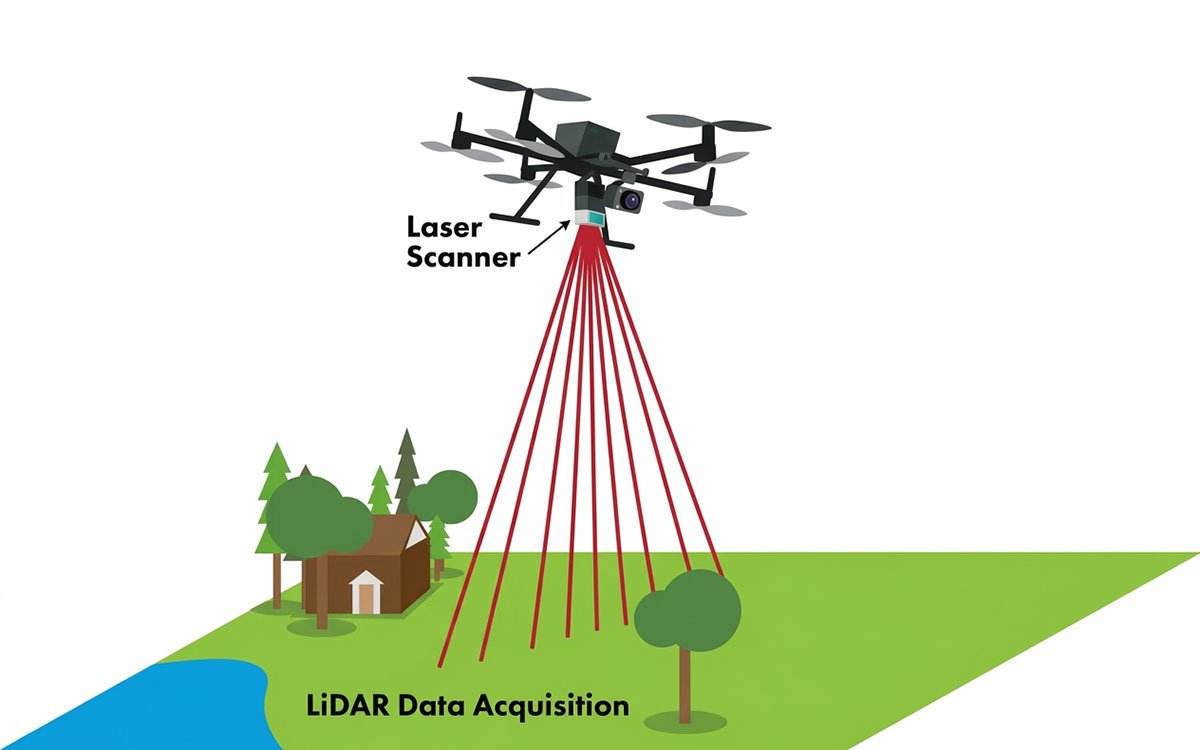
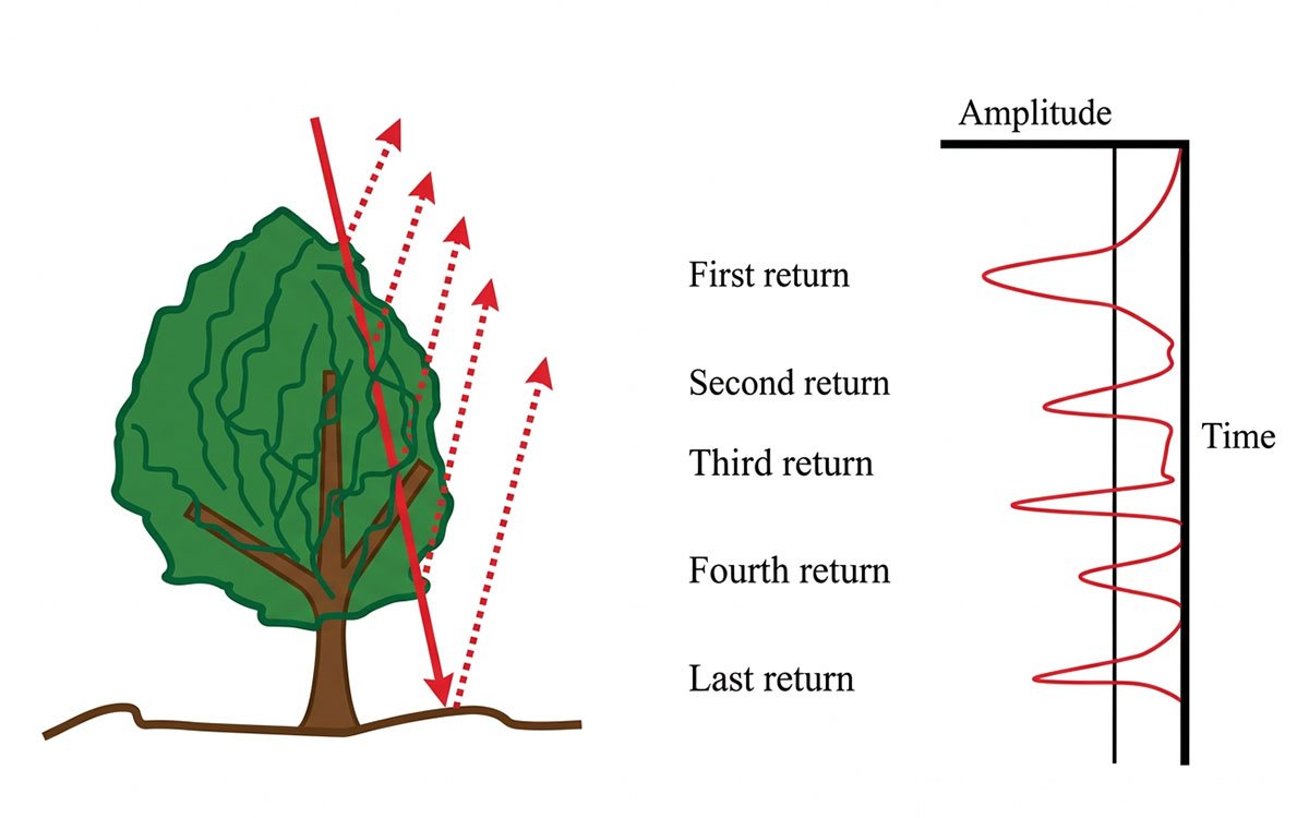
Figure 3 shows how LiDAR works. When a LiDAR laser beam hits an object, such as a tree or building, some of the light is reflected from the sensor. By accurately timing the return of each laser pulse, the LiDAR system can determine the distance to each reflected point. These calculations are based on the time-of-flight (ToF) method, which assumes a constant speed of light. The collection of points forms a so-called “point cloud,” a three-dimensional image of the scanned area consisting of points in a three-dimensional volume.
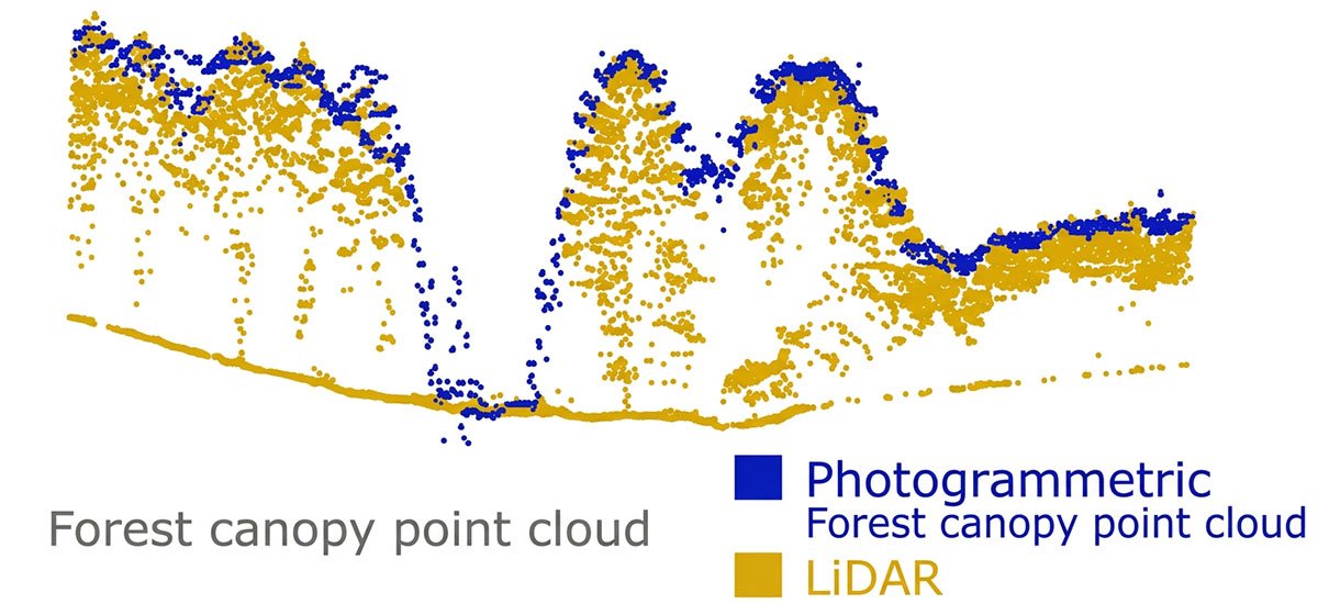
Returning to photogrammetry, the main advantage of LiDAR over photogrammetry is the ability of radiation to penetrate under vegetation, Figure 4 [8]. Thus, it provides data on the distance under tree canopies and thick grass, which photogrammetry cannot offer. Therefore, these methods are often used together, as shown in Figure 5.
Types of LiDAR Systems
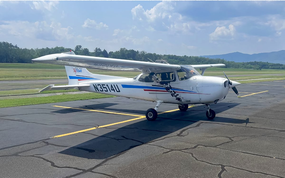
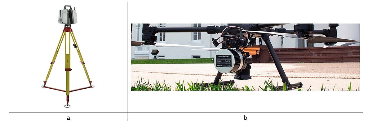
Now, let’s look at the types of lidars. There are ground-based, space-based, and airborne lidars. Ground-based lidars are mounted on tripods and have high accuracy and resolution, allowing for high detail, Figure 6 a. Airborne lidars are mounted on airplanes, but recently, the use of lidar with drones has become prevalent, Figure 6 b. Space lidars are mounted on satellites designed to scan the Earth from space [9].
Now that we have looked at how LiDAR works let’s look at its applications in the modern world.
LiDAR Applications Across Industries
LiDAR applications are not limited to simple distance measurements, like rangefinders or laser tape measures. Thanks to miniaturization, LiDAR is used in many areas, such as the most important ones:
- Autonomous vehicles
- Robotics
- Cartography and geodesy systems
- Architectural and construction design
- Security and Monitoring
- Agriculture and Natural Resource Management
- Oceanographic and marine research
- Construction
Autonomous Vehicles and Robotics
Now, let’s look at each point in more detail. The first two are similar, so we will not separate them. LiDAR is used to navigate a robot/car in a previously unknown space in robotics and autonomous vehicle navigation. Various algorithms are used for this, such as SLAM and its multiple variations [10].
Surveying and Mapping
For cartography and geodesy, LiDAR is used to obtain information about the relief of the earth’s surface, the so-called DTM (Digital Terrain Model) or DEM (Digital Elevation Model), Figure 7.
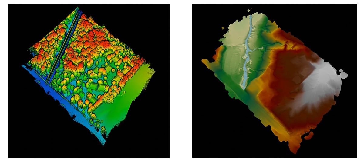
To achieve this, LiDAR is combined with an INS (inertial navigation system), which provides georeferencing of the point cloud. [11]. An example of such a system is RESEPI from Inertial Labs [12].
Architectural and construction design
LiDAR is widely used in architecture to document the process and create models for various purposes. It is often used to create mirror structures, track the progress of a project, and create 2D/3D models that can help in the construction process [13].
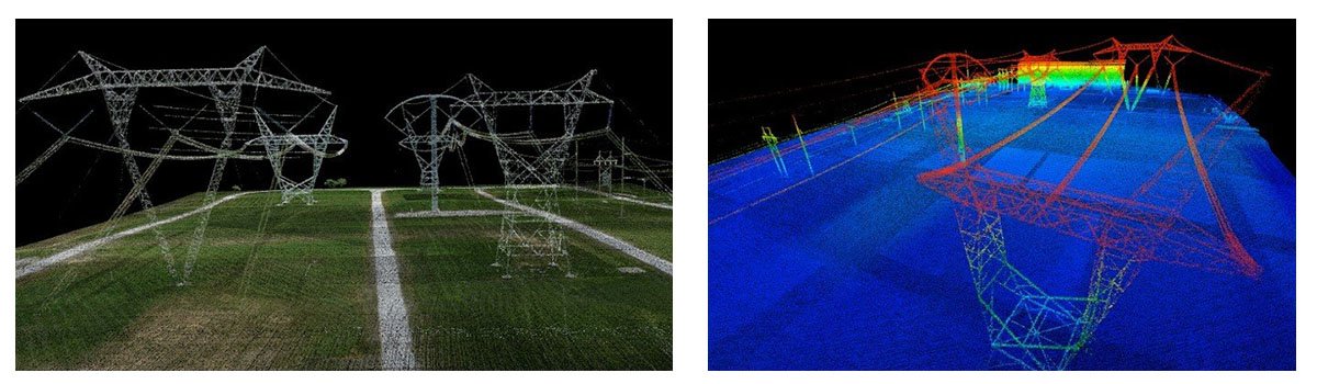
LiDAR monitors power lines because it allows long sections of lines to be surveyed quickly compared to manual methods, Figure 8 [14].
Research plant height, plant count, and other biomass estimates. Plant height and count can be easily found from LiDAR point clouds, which accurately assess each season’s yield and plant health. [15].
Oceanographic and marine research
Bathymetric lidars are used for marine research. They are used to collect data on the coastline and shallow waters. To extract information on the actual properties of the seabed to detect underwater objects [16].
Construction
In construction, lidar data helps managers effectively manage the construction process. Thanks to LiDAR, it is easy and quick to obtain an accurate, georeferenced digital map of the site where construction work is planned to analyze its quality and relief [17]. For example, the presence of slopes or holes will help to more accurately distribute the budget for soil leveling and protect against unexpected expenses in the future. During construction, point clouds will allow you to easily and quickly measure distances between objects with high accuracy, much faster than manual measurements.
It is worth noting that this is not a complete list of the niches that LiDAR has occupied recently; besides those listed, there are many others, such as manufacturing, augmented reality, etc. There is no point in considering everything since the application features are similar in many ways. Therefore, the advantages and disadvantages of LiDAR technology will be discussed below.
Advantages and Disadvantages of LiDAR Technology
Let’s consider the advantages and disadvantages of LiDAR technology.
Advantages:
- High accuracy: LiDAR provides precise distance measurements, allowing you to create detailed, high-resolution 3D maps.
- Speed: LiDAR collects data quickly, allowing it to be used in real-time, such as for navigation of autonomous vehicles.
- Light independence: Unlike cameras, LiDAR is not dependent on light levels and can work effectively both day and night.
- Penetrating Power: LiDAR can “see” through vegetation canopies and atmospheric phenomena, making it helpful in creating accurate models of the earth’s surface.
- 3D scanning: LiDAR allows you to obtain full 3D images of objects, essential for accurate mapping and modeling.
Disadvantages:
- Limited range: Despite high accuracy, the range of lidars can be limited, especially in poor visibility conditions (fog, heavy rain).
- Weather sensitivity: LiDAR may have difficulty operating in heavy rain, snow, or dust, reducing data quality.
- Data processing complexity: LiDAR generates large volumes of data that require powerful computing resources to process and interpret it.
- Power Consumption: Lidars can consume more power than other sensors, which can be critical for autonomous systems with limited resources.
- Thus, LiDAR has significant advantages in terms of accuracy and reliability, but some limitations are related to operating conditions.
RESEPI
RESEPI™ (Remote Sensing Payload Instrument) is a sensor-fusion platform for accuracy-focused remote sensing applications. RESEPI utilizes a high-performance Inertial Labs INS (GPS-Aided Inertial Navigation System) with a tactical-grade IMU and a high-accuracy single or dual-antenna GNSS receiver, integrated with a Linux-based processing core and data-logging software [18]. The platform also provides a Wi-Fi interface, optional imaging module, and external cellular modem for RTCM corrections. RESEPI can be operated by a single hardware button or from a wirelessly connected device via a simple web interface. Figure 9 shows the technical characteristics of two different RESEPI. As can be seen from the comparison of the two different systems, they have different accuracy. Inertial Labs aims to cover a wide range of tasks, so if the user is satisfied with an accuracy of about 3 cm, he will not pay more.
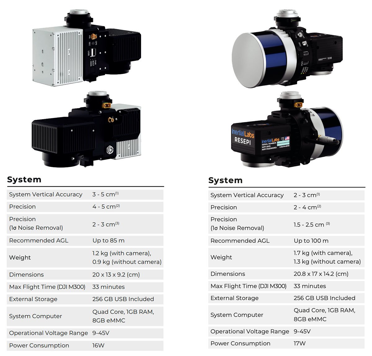
RESEPI LITE AVIA excels at surveying thin objects such as powerlines. Utility lines are extended with a small diameter and can be challenging for some lasers to track. AVIA’s high point density causes the lines to stand out and appear more clearly in point cloud data. Another great application is surveying long distances over large tracts of land, such as airport runways or racetracks. RESEPI LITE AVIA can be flown at higher speeds, and the narrow Field of View allows for preserving point cloud density. Coupled with the lighter weight of the payload, available flight time is improved.
The RESEPI LITE featuring XT-32 was strategically designed for multiple application bases. This solution is ideally suited for cost-effective surveying in open-pit mining applications, construction site monitoring, utility infrastructure management, and general volumetrics. The 360-degree FOV laser also makes this system well-suited for various platforms and operation modes, including mobile vehicles, DJI-supported drones (DJI M300, M600 Pro), custom drones, handheld platforms, cars, the Freefly Alta-X, and many more.
Thus, users can choose the ideal variant for their tasks thanks to various systems.
Conclusion
LiDAR technology appeared in the 60s of the last century, making it possible to measure relatively large distances quickly. After a long development history, this technology has found many new applications, not only as a range finder. An example is the modern use of lidars in robotics, geology, cartography, architecture, and many other areas.
Thanks to the physics of lidar, which is based on measuring the time it takes for a light beam to travel from the emitter to the object and then to the receiver, the user can collect large amounts of data quickly. Compared to other methods used long before lidar was invented, such as photogrammetry, it has a considerable advantage – penetration under tree crowns and dense vegetation. Thanks to this, geologists can obtain digital maps of the area despite the presence of biomass. However, like any other technology, LiDAR is also not without its drawbacks, the main one being sensitivity to weather conditions. But despite this, due to its advantages: high accuracy, speed of operation, and independence from the presence of lighting, as well as penetrating ability, LiDAR finds new areas of application and helps to solve a variety of problems.
References
- [1] “Colidar Mark II Used to Measure Precise Distances.” Niels Bohr Library & Archives
- [2] Wikipedia Contributors. “Lidar.” Wikipedia, Wikimedia Foundation, 13 Oct. 2019
- [3] Goyer, G. G., and R. Watson. “The Laser and Its Application to Meteorology.” Bulletin of the American Meteorological Society, vol. 44, no. 9, Sept. 1963, pp. 564–570
- [4] “Lunar Laser Ranging Experiments.” Wikipedia, 17 Oct. 2023
- [5] Wikipedia Contributors. “Photogrammetry.” Wikipedia, Wikimedia Foundation, 7 Nov. 2019
- [6] “The Mechanism of a Digital Camera / Digital Camera Basic Knowledge / PHOTO STYLE / Digital Cameras | Ricoh Global.”
- [7] Wikipedia Contributors. “Bathymetry.” Wikipedia, Wikimedia Foundation, 30 June 2024
- [8] “1.” Iitk.ac.in, 2024
- [9] Yong, Fang, et al. “Spaceborne LiDAR Surveying and Mapping.” IntechOpen EBooks, 12 July 2023
- [10] Wikipedia Contributors. “Simultaneous Localization and Mapping.” Wikipedia, Wikimedia Foundation, 8 July 2019
- [11] LIDAR + INS
- [12] “RESEPI – LiDAR Payload & SLAM Solutions.” RESEPI, 12 July 2024
- [13] “Lidar Scanning Services for Architecture | Baker Architects, LLC.” Baker Architects, 2020
- [14] “Optimizing Powerline Inspection with Advanced LiDAR Technology.” RESEPI, 19 Aug. 2024
- [15] “LiDAR Technology and Its Impact on Fertilization.” RESEPI, 10 June 2024
- [16] “Bathymetric Lidar | Hydro International.
- [17] “The Impact of LiDAR Technology on Modern Construction Practices.” RESEPI, 31 July 2024
- [18] “LiDAR Remote Sensing Payload Instrument.” RESEPI, 13 June 2023