
Overview
LiDAR (Light Detection and Ranging) technology has revolutionized the security industry by providing exact 3D mapping and environmental data, overcoming the limitations of traditional systems reliant on personnel and cameras. This article explores integrating LiDAR systems, both stationary and UAV-mounted, into modern security strategies. It highlights the strengths of LiDAR, such as accuracy, all-weather performance, and compatibility with other technologies like AI, to provide adaptable, scalable, and efficient security solutions for critical infrastructure, government facilities, and commercial enterprises. Special attention is given to drone-mounted LiDAR payloads like the RESEPI GEN-II, demonstrating their potential to redefine perimeter monitoring, threat detection, and overall situational awareness.
Here are the sections that will be covered: “Introduction to LiDAR”, “LiDAR in the Security Industry”, “How LiDAR can improve your security systems?”, and “RESEPI GEN-II is part of your security system”. The conclusion will summarize the benefits of using RESEPI GEN-II in the security system.
Section 1. Introduction to LiDAR
LiDAR is a remote sensing technology that uses laser pulses to measure the distance to objects and create highly accurate point clouds of the environment. The principle of LiDAR is based on the time it takes for a laser pulse to return to the sensor after reflecting off an object, as shown in Figure 1 [1]. Using this method, data can be collected with high accuracy, making LiDAR an ideal tool for various applications such as mapping, surveying, archaeology, and security applications.
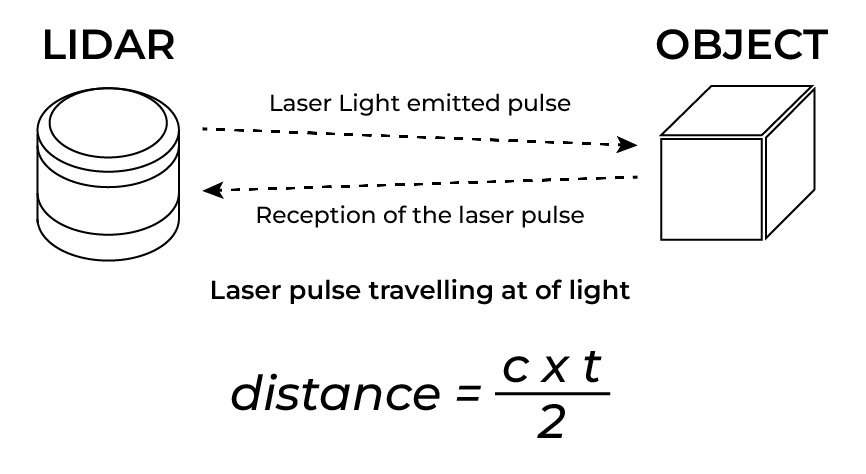 Figure 1. LiDAR operation principle.
LiDAR systems can be installed on various platforms, from satellites and airplanes to unmanned aerial vehicles (drones) and even on stationary objects.
The main advantage of LiDAR over traditional measurement methods is its high accuracy and ability to operate in low-light or harsh weather conditions. Unlike radio or sound waves in remote sensing methods, the laser beam has a smaller scattering angle, allowing for higher resolutions and more detailed data.
Since its introduction, LiDAR has made its mark in various industries and continues to evolve, opening new horizons for science, business, and engineering solutions. In recent years, LiDAR has found increasing application in site security, where accuracy and responsiveness are critical.
In the next section, we will explore the application of LiDAR technology in modern security systems.
Section 2. LiDAR in the Security Industry
Over the past decade, traditional security systems used in commercial and public institutions have included several key elements: trained personnel, video surveillance systems, and access control. In some cases, these components could provide adequate protection, but their weaknesses, which are being overcome by today’s innovative technologies, cannot be ignored.
Relying solely on surveillance cameras risks creating a false sense of security. While cameras are a vital part of a comprehensive approach, they must be complemented by other measures such as alarms, locks, and physical barriers. Over-reliance on CCTV can lead to complacency and neglect of different security aspects. It should be remembered that cameras are only one security system element.
Traditional security systems are slow to adapt to new challenges. Personnel require regular training, video surveillance equipment needs costly upgrades, and yet the facility remains vulnerable at the current moment.
While effective, modern security and perimeter security systems have several drawbacks that can limit their use in various scenarios. Let’s look at the main problems associated with traditional security methods, such as the use of cameras, dogs, and other technologies:
- CCTV cameras depend on light and weather conditions, such as fog or nighttime. And cameras may not provide sufficient image clarity despite infrared illumination under challenging conditions.
- For example, false alarms are also common due to animal movement, swaying trees, or other irrelevant objects. This leads to unnecessary strain on personnel and reduces the system’s overall efficiency.
- Cameras are limited in viewing angle and may not cover all potential threats. For example, a camera mounted on one corner of a facility may not notice an intrusion from another corner due to a blind spot or limited viewing angle.
- Dogs, like humans, can only guard a limited area, which requires considerable effort to organize patrols of extensive facilities or perimeters. The effectiveness of dogs depends on their training and physical condition, which can reduce overall guarding performance.
- Dogs may be distracted by odors or noises, making them unreliable in high winds, rain, or other adverse conditions. Dogs may also not always respond to a threat promptly, especially if the intrusion occurs at night or in situations where their ability to navigate is limited.
- People on guard duty are limited in time and speed of reaction. In extensive facilities or remote perimeters, guards may not be able to respond to a threat promptly.
- Another human factor is the potential for error due to fatigue, lack of training, or inattention. This increases the risk of missing a threat.
- Large facilities or perimeters require many personnel to secure reliably, resulting in significant labor, training, and security costs.
- Traditional perimeter security systems such as fences, chains, or barbed wire can be easily overcome by intruders, especially under challenging landscapes (e.g., mountainous or forest areas). Building and maintaining physical fencing can be expensive and require regular maintenance. Also, such systems cannot prevent aerial threats (e.g., drones), which calls into question their versatility.
Despite their popularity and use, traditional safety and security methods have several disadvantages, such as limited coverage, high cost, dependence on conditions, human error, and accuracy issues [2, 3]. In this context, technologies such as LiDAR complement these systems, offering a more accurate, reliable, and effective perimeter and facility protection solution.
Below, we look at the benefits of using LiDAR in security systems.
Section 3. How LiDAR can improve your security systems?
LiDAR provides unique opportunities to enhance site protection, improve the efficiency of security systems, and minimize false alarms [4].
One of the main security applications of LiDAR is perimeter monitoring. LiDAR systems can be installed along fences or other strategic points in the protected area. They can accurately track the movement of objects such as people, vehicles, or animals and report any suspicious activity in real-time. High measurement accuracy and the ability to operate in all conditions – at night or in bad weather – make LiDAR an ideal tool for protecting extensive facilities such as military bases, airports, and industrial plants.
LiDAR’s safety advantages:
- High accuracy and reliability. LiDAR provides accurate 3D data, eliminating errors due to ambiguous images or fuzzy contour lines, as with traditional video cameras.
- Performance in all environments. LiDAR works effectively in low-light, low-visibility, or nighttime conditions.
- Minimize false positives. With its ability to accurately capture object position and movement, LiDAR reduces false alarms, a problem with traditional security systems.
- Integration with other technologies. LiDAR can be effectively integrated with CCTV, radar, and other sensors to provide a complete security solution.
In addition, LiDAR allows you to create virtual barriers or restricted zones, as shown in Figure 2. These zones can be configured to respond to intrusions or attempts to cross a protected line, providing an instantaneous system response.
However, such systems are often limited by their static nature or dependence on complex infrastructure. The move to utilize LiDAR in conjunction with drones takes the capabilities of security systems to the next level. Flying platforms with LiDAR Payloads, such as RESEPI GEN-II, not only retain all the benefits of the technology but also add mobility, scalability, and flexibility [5]. LiDARs can now cover large areas, monitor hard-to-reach or hazardous areas, and provide real-time data.

Figure 2. A virtual barrier.
This integration opens new horizons for security, enabling faster response to threats and more effective adaptation to changing conditions. The following are key aspects of their application in this area:
- Perimeter security and area monitoring. Drones patrol the perimeter and transmit real-time data on suspicious activity (Figure 3).

Figure 3. Drone-based security system concept.
- Using UAVs protects extensive facilities (factories, warehouses, power plants) and remote areas.
- Drones follow predetermined routes and are equipped with cameras and sensors such as thermal imaging or LiDAR.
- Drones can arrive on the scene faster than security personnel, providing real-time video or 3D images.
- For dangerous situations such as fires, chemical spills, or armed attacks, drones can collect data without endangering personnel.
- Drones with AI systems can recognize faces and license plates, analyze behavior, identify suspicious activity, and produce heat maps of activity.
- Drones can work with ground-based cameras to provide different surveillance angles.
- UAVs can be equipped with smoke, gas, noise, and vibration detectors, increasing the amount of environmental information.
As a result, drones are becoming an essential part of modern security systems, providing flexibility, agility, and deep data analysis capabilities. They are already being used in critical facilities and emergencies, and their role in the future will continue to grow due to advances in technology and decreasing costs.
In the next section, let’s examine how LiDAR Payload with UAV can become part of your security system.
Section 4. RESEPI GEN-II is part of your security system
LiDAR Payload is a powerful tool for creating a high-precision security system. They allow the collection of 3D space data with high accuracy and use it for monitoring, analyzing, and preventing threats. By integrating LiDAR and IMU, the post-flight point cloud is geo-referenced with centimeter accuracy [6].
RESEPI GEN-II is an excellent example of such a payload. The RESEPI GEN-II represents the next generation of cutting-edge mapping, surveying, and autonomous navigation technology. Building on the proven performance of its predecessor, it delivers enhanced capabilities, greater versatility, and seamless integration with multiple sensors, meeting the needs of professionals across industries (Figure 4).

Figure 4. RESEPI GEN-II.
The RESEPI GEN-II offers improved hardware and firmware, delivering more accurate data collection with faster processing speeds. This advanced performance ensures users can handle large datasets and complete tasks efficiently. Payload also supports multiple sensor systems, allowing users to adapt to different project requirements [7].
Camera parameters:
- 61-megapixel Sony ILX-LR1: high resolution for colorization and photogrammetry.
- 26-megapixel Reibo R2 camera: compact and lightweight for portable installations.
Lidar options:
- XT-32M2X: provides excellent point cloud accuracy for detailed mapping.
- Ouster OS1-64: optimized for dense data collection. NDAA compliant.
Optional peripherals: extended signal outputs allow integration of multiple LiDARs, cameras, and other peripherals, providing flexibility for customization.
Automatic power switch: automatically powers up the system when connected to a power source, ideal for mission-critical scenarios where minimal user intervention is required.
Application of LiDAR Payload as part of a drone-based security system
Critical infrastructure companies, government agencies, technology startups, and integrators can use RESEPI GEN-II as a foundation for advanced solutions. Potential partners interested in building these systems have a wide range of opportunities and benefits:
- High accuracy and detail. RESEPI GEN-II creates detailed point clouds of terrain, objects, and buildings. This is particularly useful for detecting changes in the landscape or objects that may indicate disturbances. Ability to operate in limited visibility conditions (night, fog, smoke) where traditional cameras become less effective.
- Monitoring difficult-to-access and complex terrain. Using lidar on drones allows you to cover large territories and hard-to-reach areas—for example, mountainous regions, dense forests, industrial areas, or long perimeters. With RESEPI GEN-II’s capabilities, the user can access autonomous patrols with real-time analysis of collected data.
- Predicting and preventing threats. Lidar data can build digital twins of protected areas, analyze changes, and anticipate potential threats. The architecture’s flexibility allows RESEPI to be easily integrated with artificial intelligence systems to detect anomalies and send notifications automatically.
- Perimeter security. A drone with RESEPI GEN-II patrols protected areas, creating highly accurate maps and capturing any changes (e.g., new objects, breaks in the fence, or footprints on the ground).
- Real-time intrusion detection. RESEPI GEN-II helps detect unauthorized border crossings and transmits data in real-time for rapid response.
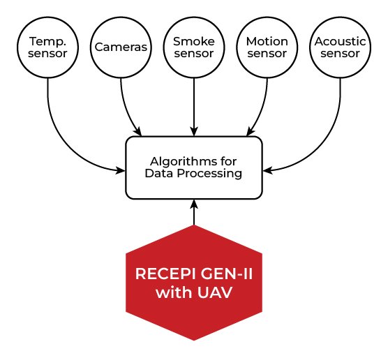 Figure 5. The future of security with RESEPI GEN-II.
- Saving time and resources. Autonomous lidar drones significantly reduce the need for manual rounds and traditional security systems.
- Increased accuracy. Eliminating human error and the ability to identify threats with centimeter accuracy.
- Scalability. Ability to adapt the system to any task, from perimeter protection of a small object to monitoring entire regions.
Lidar systems on drones are becoming essential to modern security systems, combining high accuracy, fast data processing speed, and the ability to operate in challenging environments. Potential partners, such as companies from critical infrastructure, construction, environmental monitoring, and government organizations, can create their solutions using lidar as the basis for reliable and effective protection.
Conclusion
LiDAR technology, especially when paired with UAV platforms, represents the future of security operations. Its ability to deliver accurate, real-time, and actionable insights transforms how threats are detected and managed. Adopting LiDAR-powered solutions ensures superior security, adaptability, and resource efficiency for industries managing critical infrastructure, governments, and private enterprises. The RESEPI GEN-II payload is an outstanding example of how innovation continues to redefine safety standards, providing scalable and intelligent solutions for modern security challenges.
References
[1] Wikipedia Contributors. “Lidar.” Wikipedia, Wikimedia Foundation, 13 Oct. 2019, en.wikipedia.org/wiki/Lidar.
[2] “Advantages and Disadvantages of Installing Alarm Security Systems.” GPS Security, 9 Jan. 2017, www.gps-securitygroup.com/advantages-disadvantages-installing-alarm-systems/.
[3] Mitchell, Sarah. “10 Disadvantages of CCTV: Downsides of Surveillance Systems.” Safety Is Security, 29 Nov. 2023, isecuresafety.com/10-disadvantages-of-cctv/.
[4] “Ouster.” Ouster.com, 2023, ouster.com/industries/security. Accessed 20 Dec. 2024.
[5] “RESEPI – LiDAR Payload & SLAM Solutions.” RESEPI, 12 July 2024, lidarpayload.com/.
[6] “Why Use a Survey-Grade INS on a UAV?” Inertial Labs, 25 Nov. 2024.
[7] Lidarpayload.com, 2024, lidarpayload.com/docs/connecting-to-the-resepi-payload/understanding-the-resepi-gen-ii-payload/. Accessed 20 Dec. 2024.


