Abstract
Global Navigation Satellite Systems (GNSS) play a key role in modern navigation and positioning technologies, providing accurate data in areas ranging from transportation to agriculture. However, using GNSS has several limitations that can negatively affect its effectiveness. This article discusses critical issues, including atmospheric distortion, multipath propagation, insufficient number of visible satellites, and vulnerabilities to interference and attacks. Understanding these factors is essential for developing more reliable navigation solutions and the effective use of GNSS technologies in various fields.
The sections will be covered: Introduction to GNSS, Basic Principles of GNSS operation, The limitations of GNSS, and Inertial Labs’ INS capabilities. The conclusion will summarize the limitations of GNSS and how Inertial Labs™ solutions can help you navigate without a GNSS signal.
Section 1. Introduction to GNSS
Global Navigation Satellite System (GNSS) – technology is a collection of satellite positioning systems with worldwide coverage [1]. These systems aid in positioning, navigation, and timing (PNT) applications for commercial and military purposes.
As of 2024, the following constellations are functioning: GPS (United States’s Global Positioning System), GLONASS (Russia’s Global Navigation Satellite System), BDS (China’s BeiDou Navigation Satellite System) and Galileo (European Union’s Satellite System), Figure 1 [2]. In addition, regional systems are used: QZSS (This is a regional Japanese Quasi-Zenith Satellite System) and NavIC (This autonomous system for the Indian region) [2].

Figure 1. 4 GNSS constellations.
GNSS is essential in many areas: transportation and logistics, agriculture, construction and mining, disaster emergency response systems, telecommunications and power networks, military and defense, and many others [3].
Section 2. Basic principles of GNSS operation
GNSS consists of many satellites that orbit the Earth in fixed orbits. Each satellite constantly transmits radio signals containing information about the signal’s departure time and the satellite’s orbital position. A receiving device (e.g., a smartphone or navigator) simultaneously receives signals from several satellites, Figure 2. Information from at least four satellites is required for accurate positioning; more information can be found here [4]. The system calculates the distance to each satellite based on the time it took for the signal to travel from the satellite to the receiver. Using data from multiple satellites, the receiver can pinpoint its location by three coordinates (latitude, longitude, and altitude).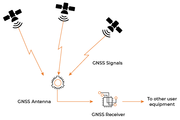 Figure 2. How GNSS works.
However, signals can be distorted due to atmospheric conditions, multipath propagation, and other factors, which will be discussed in detail below.
Section 3. The limitations of GNSS
GNSS has some limitations that can affect its accuracy and reliability. GNSS has several constraints that can affect its accuracy and reliability. Here are some of them:
- Atmospheric distortions. GNSS signals can be distorted as they pass through the atmosphere, especially in the ionosphere and troposphere, reducing positioning accuracy. Although receivers consider the correction of the signal as it passes through the ionosphere and troposphere, there are cases where disturbances occur, such as geomagnetic storms. The accuracy of the location can deteriorate significantly [5].
- Multipath propagation. When a signal bounces off buildings, mountains, or other objects, it can cause delays in its travel to the receiver, affecting the accuracy of the calculations. As buildings surround the receiver, satellite signals can be reflected and refracted, sometimes repeatedly, before finally reaching the receiver, Figure 3.
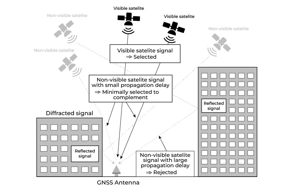
Figure 3. Multipath propagation.
- Insufficient number of satellites. In cities with tall buildings or remote areas, there may not be enough visible satellites for accurate positioning, as shown in Figure 3.
- Low power signals. GNSS signals are weak, and there may be difficulties in receiving them indoors, under dense covers, or in conditions of high electronic noise.
- Security and vulnerabilities. GNSS can be subject to attacks such as jamming, Figure 4 and spoofing, Figure 4 b, which can lead to failures in the navigation system [6].
 |  |
a | b |
Figure 4. Vulnerability to external interference: a – jamming; b – spoofing.
Jamming uses a transmitting radio frequency device to intentionally block or interfere with GPS signals. Once the interference level exceeds a specific limit, the GPS signal will be lost in the interfering signal.
Spoofing replaces the satellite signal with a false signal, causing the receiver to give false positioning. In other words, the spoofing will make the target receiver appear in a different location.
- Limited accuracy. Some applications (e.g., surveying) may require high accuracy that standard GNSS may not be able to provide without additional correction techniques.
The GNSS system cannot be called reliable, so it is often integrated with an inertial navigation system. The combination of GNSS+INS mutually compensates for the shortcomings of both systems and provides high-quality and stable navigation data output [7]. In addition, the Differential Global Positioning System (DGPS) and its various methods are used [8].
Section 4. Inertial Labs’ INS capabilities
The Inertial Labs INS-D-OEM features the top-of-the-line dual antenna Novatel OEM7220 GNSS receiver [9]. It contains a real-time spoofing detection unit that employs some of the most effective detection metrics. These metrics include input power analysis by monitoring the gain of the automatic gain control module, structural power content analysis based on the filter outputs, signal quality monitoring to monitor the peak quality affected by multipath signals, and clock monitoring using spoofing signals from a single-antenna source based on the position solution of a moving receiver.
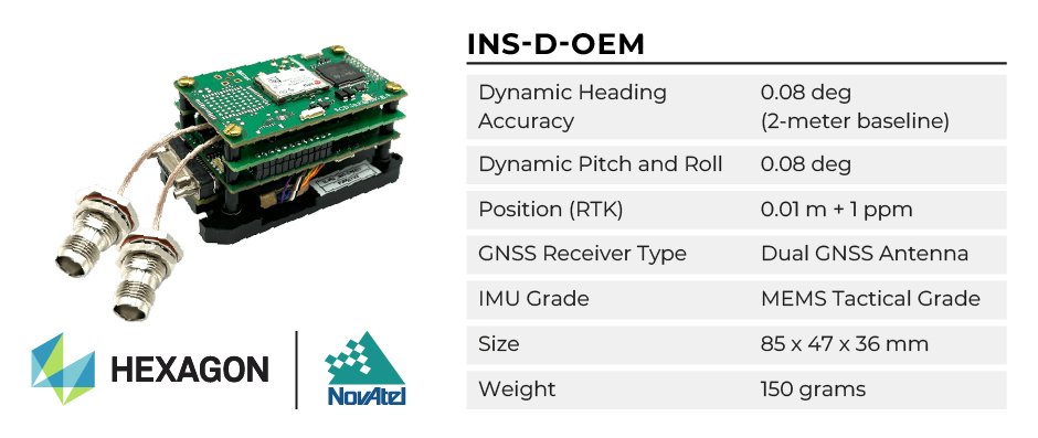
Figure 5. INS-D-OEM.
These detection metric outputs are fed to an onboard central spoofing detection unit, which decides whether the unit is under a spoofing attack every two seconds. The spoofing detection unit minimizes false detection likelihood from the presence of jamming and multipath signals while identifying spoofing attacks with a high degree of certainty.
The professional model of INS utilizes an embedded, high-precision, gyro-compensated magnetic compass, which allows the navigation system to measure and output high-precision Heading without GNSS signal even in extreme environmental conditions (temperature, vibration, interference from external magnetic field).
Inertial Labs developed the Tunnel Guide feature for the GPS-Aided INS, an advanced algorithm that implements continuous dynamic modeling for land vehicle motion [10]. As a result, the INS can mitigate errors and increase the accuracy of its MEMS IMU during prolonged GNSS outages. Now, the position error of a land vehicle remains low even in a GNSS outage area such as a tunnel, a city with signal-blocking buildings, or any location where satellite communication is being blocked, spoofed, or jammed.
The Tunnel Guide feature has proven to be an effective solution for military vehicles such as Infantry Carrier Vehicles (ICV), Mobile Gun Systems (MGS), Anti-Tank Guided Missile Vehicles (ATGM), Anti-Drone Guided Missile Vehicles (ADGMV), NBC Reconnaissance Vehicles (NBCRV), Assault Amphibious Vehicles (AAV), and Light Armored Multipurpose Vehicles (LAMV).
Conclusion
Global Navigation Satellite Systems (GNSS) have become integral to our daily lives, providing navigation and positioning in various areas. However, despite their widespread adoption and usefulness, GNSSs face some significant limitations. These include problems with atmospheric distortions, signals multipath propagation, insufficiently visible satellites under challenging environments, and potential safety hazards. These factors can significantly reduce the accuracy and reliability of a system in mission-critical applications such as transportation, surveying, and military operations.
Navigation systems from Inertial Labs solve these problems and provide users with high-quality and reliable navigation data without a GNSS signal.
The Inertial Labs team of skilled engineers provides expertise to help users select and configure from the available models. Our support team helps set up units for all application bases to satisfy GNSS-enabled and GNSS-denied environments.
References
[1] Wikipedia. “Satellite Navigation.” Wikipedia, 19 Mar. 2020, en.wikipedia.org/wiki/Satellite_navigation.
[2] Mendez, Maria. “An In-Depth Look at the Principles of GNSS.” Inertial Labs, 23 Aug. 2024, inertiallabs.com/an-in-depth-look-at-the-principles-of-gnss/. Accessed 25 Sept. 2024.
[3] “GNSS Applications.” Wikipedia, 10 Jan. 2021, en.wikipedia.org/wiki/GNSS_applications.
[4] Jan Van Sickle. GPS for Land Surveyors. Boca Raton, Crc Press, Taylor & Francis Group, 2015.
[5] “Space Weather and GPS Systems | NOAA / NWS Space Weather Prediction Center.” Www.swpc.noaa.gov, www.swpc.noaa.gov/impacts/space-weather-and-gps-systems.
[6] “Understanding the Difference between Anti-Spoofing and Anti-Jamming.” Novatel.com, novatel.com/tech-talk/velocity-magazine/velocity-2013/understanding-the-difference-between-anti-spoofing-and-anti-jamming#:~:text=Generally%20speaking%2C%20adversaries%20may%20attempt.
[7] Grewal, Mohinder S, et al. Global Positioning Systems, Inertial Navigation, and Integration. John Wiley & Sons, 5 Mar. 2007.
[8] Wikipedia Contributors. “Differential GPS.” Wikipedia, Wikimedia Foundation, 16 Apr. 2019, en.wikipedia.org/wiki/Differential_GPS.
[9] Rudenko, Roman. “Inertial Labs INS-D-OEM with Spoofing Protection.” Inertial Labs, Mar. 2021.
[10] Rudenko, Roman. “Tunnel Guide” Feature for GPS-Aided INS Improves Performance during GNSS Outage.” Inertial Labs, 27 July 2020.