
OPUS (Online Positioning User Service) is an online service for processing global positioning system (GPS) data developed and maintained by the US National Geodetic Survey (NGS), part of the National Oceanic and Atmospheric Administration (NOAA) [1].
OPUS is utilized in surveying, cadastral mapping, construction, monitoring, and scientific research.
This service allows users to upload raw GPS measurements (typically in RINEX format) and obtain high-precision coordinates using a network of continuously operating reference stations (CORS), as shown in Figure 1.
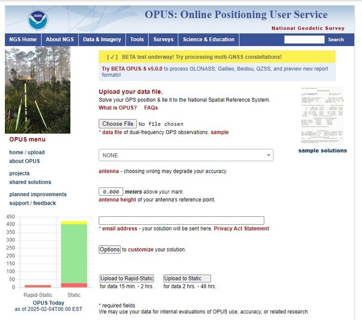
Figure 1. User data upload page in OPUS.
The service is designed for user simplicity. The entire process can be completed in three steps:
1) Upload dual-frequency static GPS (L1/L2) measurements.
2) Select the antenna used to receive the signal and its height relative to the ground mark.
3) Choose the processing mode, which we will examine in detail below, and provide an email address to receive the results.
After submission, the server begins processing the data. Processing is available in two modes:
1) Static (S)
2) Rapid-Static (RS)
In Static mode, data files ranging from 2 to 48 hours are processed, with coordinates derived as an average of three independent solutions, each based on double-difference carrier phase measurements from one of three nearby CORS. In Rapid-Static mode, files are processed from 15 minutes to 2 hours. This mode has stricter requirements for data continuity and geometry, meaning OPUS-RS may not work in remote areas with limited CORS coverage.
OPUS Accuracy
Now, let’s consider the accuracy of the results. In general, OPUS provides position estimates with centimeter-level precision. However, specific errors, such as those arising from incorrect antenna selection, are not detected. Accuracy is also affected by multipath effects and atmospheric conditions. To improve accuracy, users are advised to extend observation times, conduct repeated measurements, use different equipment, or adjust observation times (e.g., to a different day or time of day). Additionally, submitting data for processing on the following day can improve accuracy, as fast orbits become available at 17:00 UTC the next day.
Collaborative contribution
If desired, users can share their calculation results with others, provided the data meets the requirements shown in Figure 2.
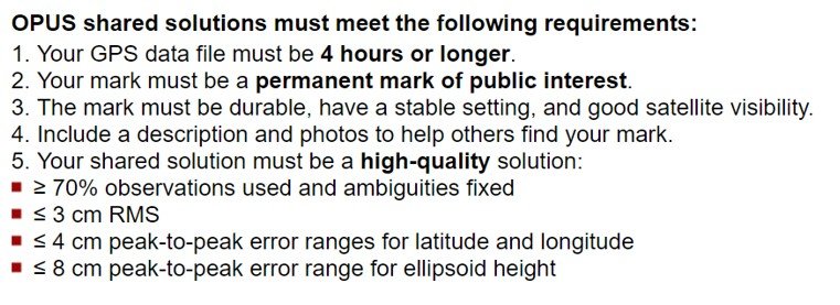
Figure 2. User data requirements for sharing the solution.
This feature helps maintain local ties to the National Spatial Reference System (NSRS), enhancing geodetic consistency.
OPUS Projects
OPUS Projects offers users enhanced data management capabilities. Key features include:
1) Automated CORS inclusion and data quality control. CORS used in individual OPUS-S solutions is automatically integrated into the project. Users can also select additional reference stations based on their characteristics. OPUS-Projects performs simultaneous coordinate calculations for both survey points and CORS. Comparing the obtained values with the published coordinates of the reference stations enables the prompt identification of possible discrepancies, which may be associated with both survey errors and anomalies in the operation of individual CORS at the time of observation.
2) Optimization of the observation network structure. By default, OPUS Projects offers a network configuration based on the recommended NGS “hub-and-spoke” design, where the most central CORS is designated as a hub, and the remaining points are connected radially (spokes). However, users can specify alternative network topologies according to project requirements.
3) The step-by-step process of network adjustment uses the least-squares method. OPUS Projects includes five stages of network adjustment, implemented using the least-squares method. At each stage, users are provided with analytical information to check the accuracy of calculations, along with recommendations for imposing necessary constraints. If the project contains descriptive files with NGS data, the system automatically uses published coordinates and elevations to improve calculation accuracy.
4) Automation of the data transfer process to NGS. OPUS-Projects simplifies the process of transferring GPS survey results to the National Geodetic Survey (NGS) for subsequent publication. Traditional data preparation processes (“bluebooking”) are performed automatically, and the user only needs to follow step-by-step instructions to set up the network and upload accompanying files.
OPUS-Projects ensures efficient management of satellite geodetic measurements, providing tools for analyzing, optimizing, and publishing high-precision data.
Not only OPUS
In addition to OPUS, other services support the post-processing of user data. The website [2] provides a relatively comprehensive comparison of the accuracy of various services with the results of OPUS, namely:
1) CSRS-PPP: Canadian Spatial Reference System, Natural Resources Canada [3].
2) AUSPOS: Geoscience Australia [4].
3) GAPS: University of New Brunswick [5].
4) APPS: Jet Propulsion Laboratory [6].
5) SCOUT: Scripps Orbit and Permanent Array Center (SOPAC), University of California, San Diego [7].
6) magicGNSS: GMV [8].
7) CenterPoint RTX: Trimble Navigation [9].
According to the research, the AUSPOS service was the most accurate, as shown in Figure 3. The results of the research are shown in Figure 4.
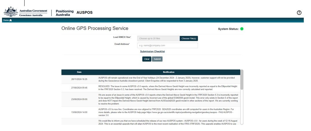
Figure 3. User data upload page in AUSPOS.
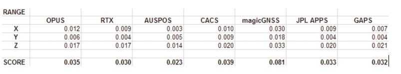
Figure 4. Accuracy comparison results [10].
The same conclusion was reached in other studies. For example, one study compares the accuracy of five online services: AUSPOS, CSRS-PPP, magicGNSS, APPS, and GAPS [11]. The research results are shown in Figure 5.
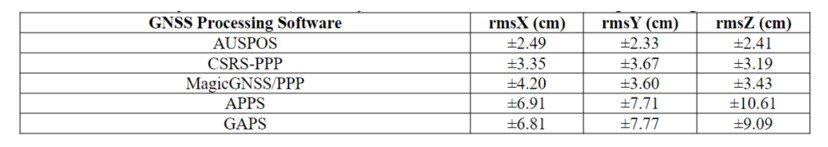
Figure 5. Accuracy assessment (Summary of RMSEs of the Online GNSS processing service) [11].
Thus, users have several highly accurate alternatives. The processing, storage, and formatting capabilities provided by OPUS and similar services make survey results more consistent, reliable, and accessible.
OPUS is a highly effective tool for GNSS data processing, delivering high-precision coordinate determination under specific conditions, including correct antenna selection, atmospheric considerations, and multipath mitigation. The development of OPUS Projects expands system capabilities, offering automated tools for managing geodetic data. While OPUS remains one of the most widely used services, research indicates that alternatives, such as AUSPOS, can provide comparable or even superior accuracy. The availability of multiple services enables users to select the most suitable tool based on survey conditions and accuracy requirements.
References
[1] US Department of Commerce, NOAA. “OPUS: The Online Positioning User Service, Process Your GNSS Data in the National Spatial Reference System.” Geodesy.noaa.gov, geodesy.noaa.gov/OPUS/.
[2] Gakstatter, Eric. “A Comparison of Free GPS Online Post-Processing Services – GPS World.” GPS World, 7 Oct. 2013, www.gpsworld.com/a-comparison-of-free-gps-online-post-processing-services/. Accessed 5 Feb. 2025.
[3] “Precise Point Positioning.” Webapp.csrs-Scrs.nrcan-Rncan.gc.ca, webapp.csrs-scrs.nrcan-rncan.gc.ca/geod/tools-outils/ppp.php.
[4] “GNSS Network Portal.” Gnss.ga.gov.au, gnss.ga.gov.au/auspos.
[5] “GAPS – Home.” Gge.unb.ca, 2016, gaps.gge.unb.ca/. Accessed 5 Feb. 2025.
[6] Gdgps.net, 2025, pppx.gdgps.net//. Accessed 5 Feb. 2025.
[7] “SCOUT Scripps Coordinate Update Tool.” Ucsd.edu, 2025, sopac-old.ucsd.edu/scout.shtml. Accessed 5 Feb. 2025.
[8] “MagicGNSS.” Gmv.com, 2022, magicgnss.gmv.com/. Accessed 5 Feb. 2025.
[9] “Trimble CenterPoint RTX Post-Processing Service.” Trimblertx.com, 2025, www.trimblertx.com/. Accessed 5 Feb. 2025.
[10] Gakstatter, Eric. “A Comparison of Free GPS Online Post-Processing Services – GPS World.” GPS World, 7 Oct. 2013, www.gpsworld.com/a-comparison-of-free-gps-online-post-processing-services/. Accessed 5 Feb. 2025.
[11] TATA, Herbert “Comparative Analysis of Different Online GNSS Processing Services.” Lagos Journal of Environmental Studies, vol. 10, no. 1, 2019, pp. 1–12, ljes.unilag.edu.ng/article/view/941. Accessed 5 Sept. 2024.