 |
 |
 |
 |
 |
|
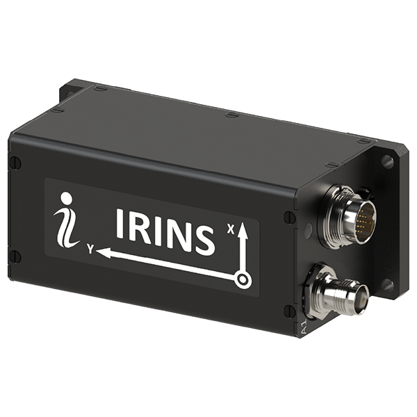
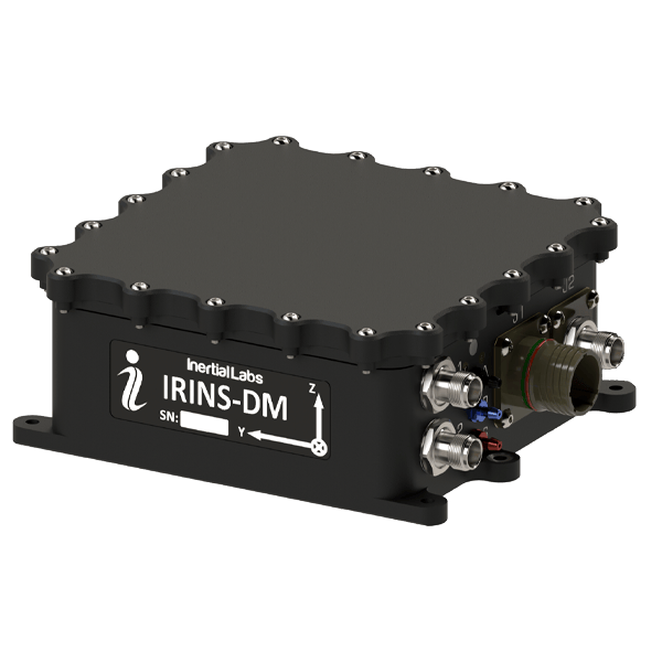
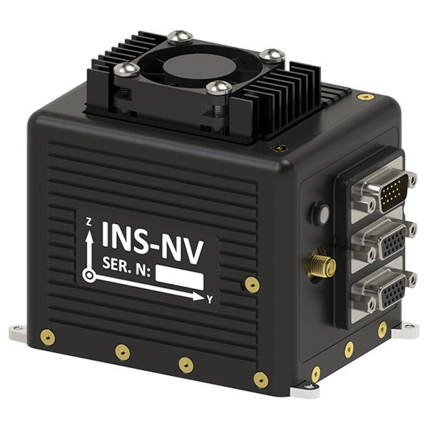
| INS-U | VINS | IRINS | IRINS-DM | INS-NV | |
| Inertial Navigation System with embedded air data computer for flight control in fixed wing applications | Complete visual navigation system with modular design made to withstand varying environmental conditions | Inertial Navigation System with embedded LEO receiver for absolute navigation in contested environments | Inertial Navigation System with embedded LEO and GNSS receivers for absolute navigation in contested and GNSS-denied environments | Programmable inertial navigation system with fast processing and industry standard interfaces for easy integration in legacy platforms | |
| - | - | ||||
| GNSS-Denied Position Accuracy | 1% DT | <35 m, RMS | 80 m, RMS | 50 m, RMS | Dependent on Platform |
| GNSS-Denied Velocity Accuracy | 0.5 m/s | < 0.9 m/s | 2 m/s | < 0.1 m/s | Dependent on Platform |
| Jamming and Spoofing Mitigation? | YES | YES | YES | YES | YES |
| Size | 82 x 40 x 26 mm |
Sensor Module: 83 x 100 x 80 mm Processing Module: 80 x 45 x 134 mm |
120 x 50 x 53 mm 86 x 51 x 48 mm (OEM) |
160.4 × 141.2 x 61.1 mm |
111 x 75 x 92 mm 107 x 68 x 92 mm (OEM) |
| Weight | < 200 grams |
Sensor Module: 330 grams Processing Module: 420 grams |
220 grams 80 grams (OEM) |
1400 grams | 480 grams |
| Input Voltage | 5-32 V DC | 9-36 V DC | 9-36 V DC | 9-36 V DC | 9-36 V DC |
| Power Consumption | <2 W | 10 W | <8 W | <10 W | 15 W |
| Interfaces | RS-232, RS-422, RS-485 | RS-232, RS-422, Ethernet | RS-232, RS-422, CAN, Ethernet | RS-232, RS-422, CAN, Ethernet, RF | RS-232, RS-422, Ethernet, GPIO, USB 2.0, PPS output, Camera Strobe I/O |
| Datasheet | Coming Soon |
|
|
|
|
|
|
|
| INS-U | VINS | IRINS | IRINS-DM | INS-NV | |
| Inertial Navigation System with embedded air data computer for flight control in fixed wing applications | Complete visual navigation system with modular design made to withstand varying environmental conditions. | Inertial Navigation System with embedded LEO receiver for absolute navigation in contested environments | Inertial Navigation System with embedded LEO and GNSS receivers for absolute navigation in contested and GNSS-denied environments | Programmable inertial navigation system with fast processing and industry standard interfaces for easy integration in legacy platforms | |
| - | - | ||||
| GNSS-Denied Position Accuracy | 1% DT | <35 m, RMS | 80 m, RMS | 50 m, RMS | Dependent on Platform |
| GNSS-Denied Velocity Accuracy | 0.5 m/s | < 0.9 m/s | 2 m/s | <0.1 m/s | Dependent on Platform |
| Jamming and Spoofing Mitigation? | YES | YES | YES | YES | YES |
| Size | 82 x 40 x 26 mm |
Sensor Module: 83 x 100 x 80 mm Processing Module: 80 x 45 x 134 mm |
120 x 50 x 53 mm 86 x 51 x 48 mm (OEM) |
160.4 x 141.2 x 61.1 mm |
111 x 75 x 92 mm 107 x 68 x 92 mm (OEM) |
| Weight | < 200 grams |
Sensor Module: 330 grams Processing Module: 420 grams |
220 grams 80 grams (OEM) |
1400 grams | 480 grams |
| Input Voltage | 5-32 V DC | 9-36 V DC | 9-36 V DC | 9-36 V DC | 9-36 V DC |
| Power Consumption | <2 W | 10 W | <8 W | <10 W | 15 W |
| Interfaces | RS-232, RS-422, RS-485 | RS-232, RS-422, Ethernet | RS-232, RS-422 , CAN, Ethernet | RS-232, RS-422, CAN, Ethernet, | RS-232, RS-422, Ethernet, GPIO, USB 2.0, PPS output, Camera Strobe I/O |
| Datasheet (PDF) | Coming soon |
 |
 |
 |
 |
 |
|
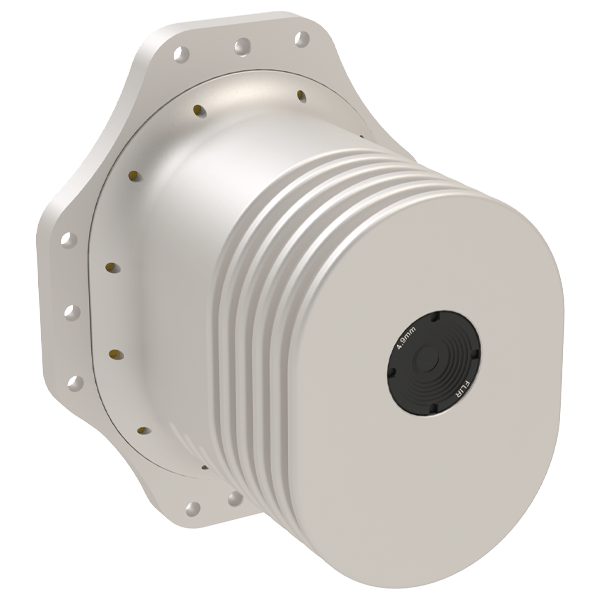
| M-AJ-QUATRO | Air Data Computer | DTC BluSDR-30 | DWS FT743-SM | Speed Wedge MKII | |
| Controlled Radiation Pattern Antenna (CRPA) technology alongside state-of-the-art signal processing capabilities, delivering enhanced jamming mitigation for critical applications. | Standalone air data computer compatible with all Inertial Labs INS devices capable of outputting pressure altitude, air speed, air density, and outside air temperature | Software defined radios that perform RF ranging by generating low probability of interception/detection (LPI/LPD) mesh-based time of flight (ToF) packets. These serve as aiding data streams for IL’s cutting-edge inertial navigation solutions capable of performing advanced sensor fusion for GNSS-denied position triangulation. | Digital wind sensor capable of measuring wind speeds up to 75m/s in harsh environments where there is significant vibration or electrical noise | True-ground speed sensor and active motion detector for moving objects, based on Radar Doppler technology, capable of measuring speed up to 200 km/h | |
| Application | Interference suppression in GNSS contested environment | Aiding data for navigation systems in VTOL and fixed-wing UAVs | Aiding data for absolute positioning and navigation in aerial applications | Aiding data for navigation systems in multirotor and helicopter UAVs | Aiding data for navigation of unmanned ground vehicles (UGVs) and rail applications |
| Datasheet |
|
|
|
|
|
|
|
| M-AJ-QUATRO | Air Data Computer | DTC BluSDR-30 | DWS FT743-SM | Speed Wedge MKII | |
| Controlled Radiation Pattern Antenna (CRPA) technology alongside state-of-the-art signal processing capabilities, delivering enhanced jamming mitigation for critical applications. | Standalone air data computer compatible with all Inertial Labs INS devices capable of outputting pressure altitude, air speed, air density, and outside air temperature | Software defined radios that perform RF ranging by generating low probability of interception/detection (LPI/LPD) mesh-based time of flight (ToF) packets. These serve as aiding data streams for IL’s cutting-edge inertial navigation solutions capable of performing advanced sensor fusion for GNSS-denied position triangulation. | Digital wind sensor capable of measuring wind speeds up to 75m/s in harsh environments where there is significant vibration or electrical noise | True-ground speed sensor and active motion detector for moving objects, based on Radar Doppler technology, capable of measuring speed up to 200 km/h | |
| Application | Interference suppression in GNSS contested environment | Aiding data for navigation systems in VTOL and fixed-wing UAVs | Aiding data for absolute positioning and navigation in aerial applications | Aiding data for navigation systems in multirotor and helicopter UAVs | Aiding data for navigation of unmanned ground vehicles (UGVs) and rail applications |
| Datasheet |