The Challenge
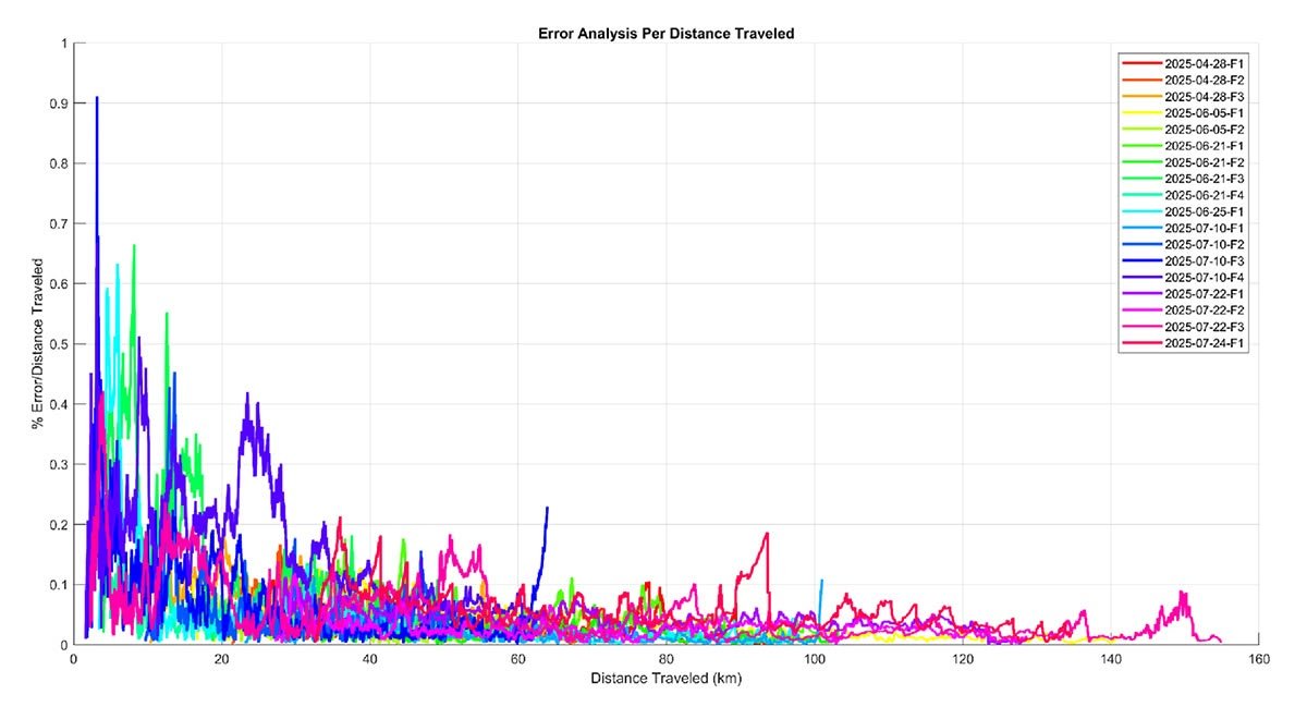
In GNSS-denied environments, conventional navigation systems relying solely on inertial sensors experience rapid error accumulation due to uncorrected drift. This results in unreliable position estimates and limits mission continuity. The challenge addressed in this campaign was to demonstrate that VPS and VIO could maintain stable, accurate GPS-denied navigation across extended flight segments over distances up to 150 km — without a single satellite fix.The Solution
The VINS integrates visual map matching (VPS) with VIO in a tightly coupled sensor fusion architecture. Real-time imagery captured by the day and infrared cameras is compared against onboard 3D satellite maps to generate absolute position updates. These updates are fused in an Extended Kalman Filter to correct the INS (Inertial Navigation System), significantly reducing drift. When VPS confidence drops, VIO maintains continuity — making this a robust solution for autonomous navigation without GPS.
The Method
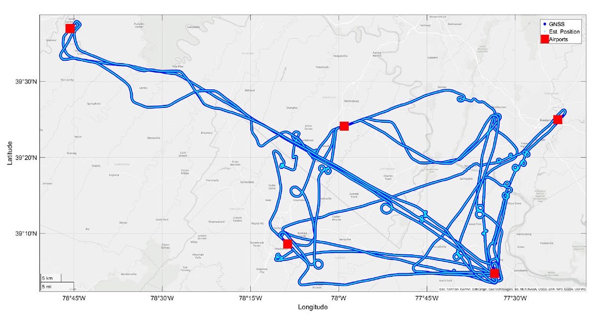
A total of 18 flight datasets were collected, with GNSS intentionally disabled during segments of up to 46 minutes and distances up to 150 km. Test altitudes ranged from 200 to 2,000 meters AGL. The flights included diverse maneuvers and environmental conditions to challenge the system, ensuring realistic evaluation across customer use cases in defense and commercial aviation.
The Results
Table 1.| Flight ID | Position Error (m) | Max AGL (m) | Avg AGL (m) | Flight Duration (min) | GNSS-Denied Time (min) | GNSS-Denid Distance (km) |
|---|---|---|---|---|---|---|
|
2025-04-28-F1 |
14.32 |
1070.37 |
602.59 |
30.88 |
23.55 |
69.73 |
|
2025-04-28-F2 |
8.70 |
856.33 |
586.25 |
28.59 |
20.22 |
48.50 |
|
2025-04-28-F3 |
12.17 |
981.43 |
558.54 |
23.71 |
19.06 |
56.77 |
|
2025-06-05-F1 |
18.31 |
2078.25 |
1024.42 |
49.81 |
44.13 |
125.56 |
|
2025-06-05-F2 |
7.15 |
346.17 |
256.36 |
22.07 |
15.36 |
40.26 |
|
2025-06-21-F1 |
17.60 |
362.28 |
227.88 |
40.23 |
22.09 |
69.77 |
|
2025-06-21-F2 |
8.08 |
363.63 |
229.88 |
40.03 |
21.88 |
69.53 |
|
2025-06-21-F3 |
23.42 |
350.45 |
188.95 |
22.07 |
15.49 |
45.56 |
|
2025-06-21-F4 |
9.07 |
350.26 |
190.10 |
21.99 |
15.10 |
44.70 |
|
2025-06-25-F1 |
9.38 |
339.39 |
251.18 |
34.33 |
31.19 |
93.68 |
|
2025-07-10-F1 |
7.81 |
667.33 |
316.07 |
32.09 |
24.84 |
77.77 |
|
2025-07-10-F2 |
9.92 |
570.50 |
329.27 |
22.74 |
18.90 |
52.84 |
|
2025-07-10-F3 |
14.78 |
999.12 |
555.89 |
22.79 |
21.84 |
62.15 |
|
2025-07-10-F4 |
35.09 |
999.79 |
2558.91 |
22.68 |
21.79 |
62.36 |
|
2025-07-22-F1 |
14.72 |
1285.08 |
922.00 |
36.81 |
28.32 |
101.15 |
|
2025-07-22-F2 |
11.38 |
1286.80 |
924.53 |
36.81 |
28.35 |
101.31 |
|
2025-07-22-F3 |
25.28 |
789.48 |
395.72 |
47.41 |
46.28 |
152.61 |
|
2025-07-24-F1 |
29.60 |
712.23 |
377.74 |
38.61 |
28.88 |
102.23 |
The Discussion
Across all flights, the VINS system achieved a mean position error of 16.55 meters, demonstrating highly stable GNSS-denied navigation over extended operations. The infrared camera (mean error 15.88 m) consistently outperformed the daylight camera (mean error 18.08 m), providing improved tracking under low-light and complex environmental conditions.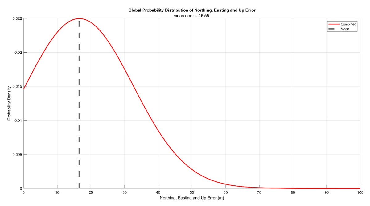
The Benefits
Business Impact:- Reliable visual-inertial navigation over 150 km without GNSS
- Sub-20 meter average error across diverse terrain and lighting conditions
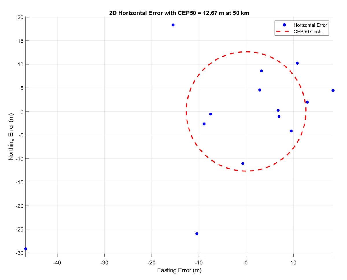
- CEP50 of 12.67 m ensures tightly clustered position estimates
- Scalable for defense and commercial aviation applications
Explore Inertial Labs’ related solutions:

Ready to navigate without GPS?
Contact the Inertial Labs team to discuss VINS GNSS-denied navigation for your platform and mission requirements.
Tel.: +1 (703) 880-4222
E-mail: il.sales@viavisolutions.com
Adresse: 39959 Catoctin Ridge St, Paeonian Springs, VA 20129, USA
inertiallabs.com