
Tactical Vehicle Navigation System (CheetahNAV)
CheetahNAV is a complete crew-facing navigation system rather than a sensor: a sunlight-readable moving map, a driver’s repeater display, and an Inertial Labs INS underneath it. It is ITAR-free, vehicle agnostic, and at Technology Readiness Level 9 — already fielded, not a development programme.
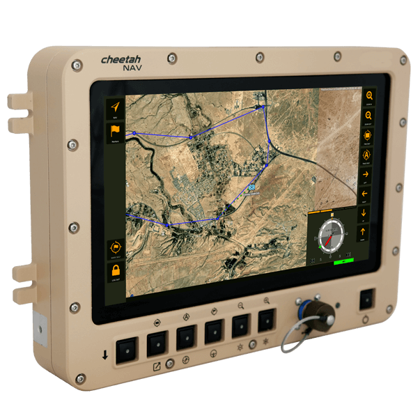
What the crew sees
The main display unit is an 11.6-inch 16:9 TFT at 1920 × 1080, sunlight readable with resistive touch. It shows current vehicle speed and true heading, current position, desired heading and speed to reach the next waypoint on time, distance to that waypoint, pitch and roll attitude, and the track already travelled. Symbology follows MIL-STD-2525B. A separate 3.5-inch driver display unit repeats the essentials over PoE Ethernet or RS-422. A multi-language pack supports joint multinational operations.
Navigation performance
Static heading accuracy is 1.0° RMS with the INS-B fitted, or 0.08° with the INS-D. Gyrocompassing reaches better than 0.16° RMS × sec Lat using the optional FOG IMU. Pitch and roll: 0.06° static, 0.03° dynamic with GNSS. Horizontal position is 1.8 m RMS with GNSS, and dead reckoning holds 0.2% of distance travelled once the filter has converged. IMU data streams at 2000 Hz, INS solutions at 200 Hz.
Qualification
MIL-STD-810G across operational vibration for Category 20 ground vehicles, 40 g functional shock, humidity, sand and dust, and storage altitude to 15 km. MIL-STD-461F Class B EMC. Input 28 V DC to MIL-STD-1275E. MTBF 15,000 hours at 55 °C ground mobile. Operating -20 to +71 °C.
Optional capability
Battle management system integration, freeform messaging, GNSS anti-spoofing and anti-jamming, additional displays, external IP or SDI video input processing, HD display sharing with other vehicle systems, and localisation of production.
Key features benefits & functionality
- ITAR-Free
- Route planning functionality
- Improved situational awareness
- Enhances mobility of vehicles
- Real time tactical moving map
- Multi language pack
- MIL-STD-2525B symbology
- Touch screen display
- Optional localization of production
- Ruggedized design
- Compact, MIL-STD qualified Inertial Navigation System (INS)
- Embedded GNSS receiver (uBlox / Novatel)
- Tactical-grade MEMS or FOG IMU
- Dead reckoning accuracy within 0.2% of distance traveled (DT)
- Technology Readiness Level (TRL 9)
- Affordable price
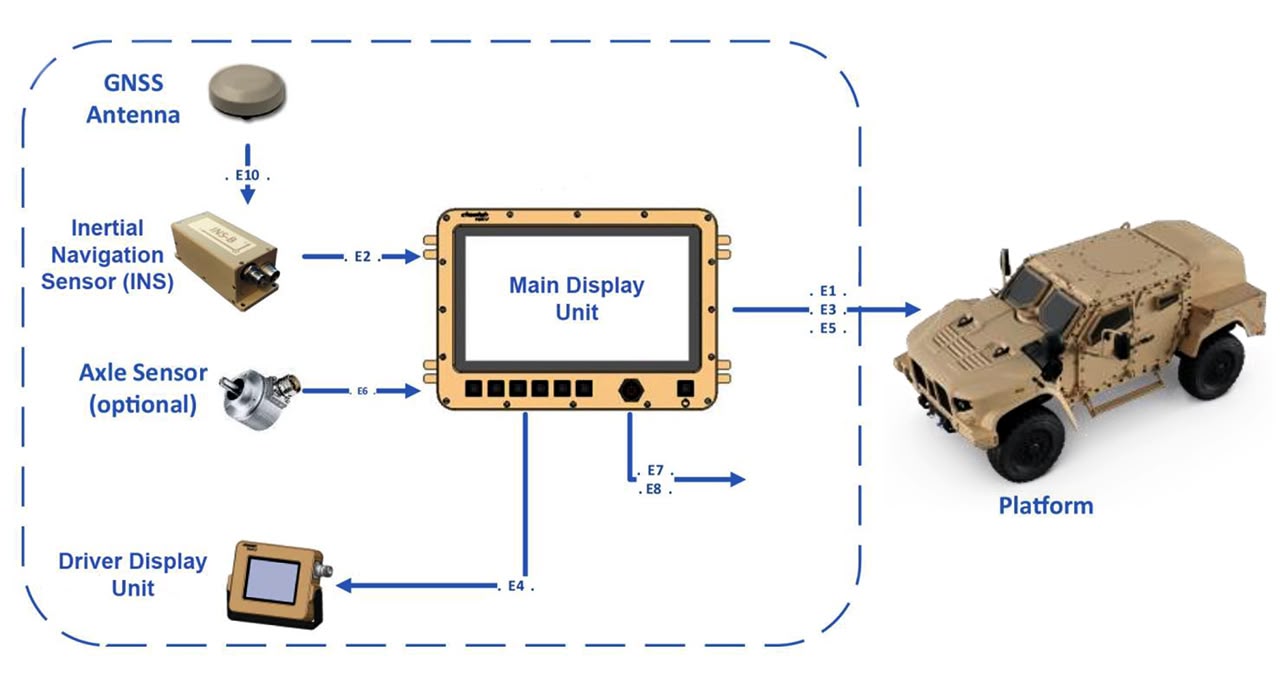
System Architecture & Connection Diagram
CheetahNAV Main Specifications
| Parameter | CheetahNAV |
|---|---|
| Heading Accurasy | 3 MIL (INS-B); 1 MIL (INS-D) |
| Position Accuracy | 1cm (RTK), 2.5cm (PPP), 60cm (SBAS) |
| Pitch & Roll Accuracy | 0.5 MIL |
| GNSS Constellations | BDS, GAL, GLO, GPS, QZSS, IRNSS (NavIC) |
| Corrections | DGPS, PPK, PPP, RTK, SBAS |
| Type of IMU | MEMS, Tactical-grade, FOG IMU Optional |
| Magnetometer | External Magnetic Compass (optional) |
| Other Features | Battle management system integration, Freeform messaging Anti GNSS spoofing and jamming, Additional displays |
| Size (mm) |
MDU: 322 x 233 x 50 DDU: 128 x 100 x 34 INS: 120 x 50 x 53 |
| Weight (gram) |
MDU: 4050 DDU: 650 INS-B: 220 INS-D: 320 |
Related Products
Trademark Legal Notice: All product names, logos, and brands are the property of their respective owners. All company, product, and service names used in this document are for identification purposes only. Use of these names, logos, and brands does not imply endorsement. ABS, BeiDou, Cobham Limited, EdgeTech, Galileo, GLONASS, GPS, Hexagon, HYPACK, IMAGENEX, Kongsberg Seatex, LabVIEW, Livox, Norbit, NovAtel, NovAtel Inertial Explorer, Ouster, Qinsy, Quanergy, QZSS, R2Sonic, RIEGL, ROCK Robotic, ROS, Septentrio, Ship Motion Control SMC, Teledyne TSS, u-blox, Velodyne, WAASP, Waypoint.